| Geodesy |
|---|
 |
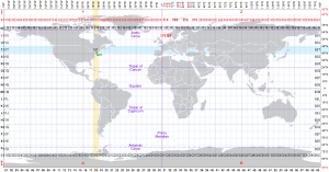
The Universal Transverse Mercator (UTM) is a map projection system for assigning coordinates to locations on the surface of the Earth. Like the traditional method of latitude and longitude, it is a horizontal position representation, which means it ignores altitude and treats the earth surface as a perfect ellipsoid. However, it differs from global latitude/longitude in that it divides earth into 60 zones and projects each to the plane as a basis for its coordinates. Specifying a location means specifying the zone and the x, y coordinate in that plane. The projection from spheroid to a UTM zone is some parameterization of the transverse Mercator projection. The parameters vary by nation or region or mapping system.
Most zones in UTM span 6 degrees of longitude, and each has a designated central meridian. The scale factor at the central meridian is specified to be 0.9996 of true scale for most UTM systems in use.[1][2]

- ^ "Universal Transverse Mercator (UTM)". PROJ coordinate transformation software library.[permanent dead link]
- ^ Snyder, John P. (1987). Map projections: A working manual. U.S. Government Printing Office.