University District | |
|---|---|
District of Spokane | |
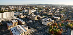
 Spokane's University District is pictured in the upper-right half of this 2015 image, looking northeast from Downtown Spokane. | |
 | |
| Coordinates: 47°39′40.1″N 117°24′20.9″W / 47.661139°N 117.405806°W | |
| Country | United States |
| State | Washington |
| County | Spokane |
| City | Spokane |
| Time zone | UTC-8 (PST) |
| • Summer (DST) | UTC-7 (PDT) |
| ZIP Codes | 99202, 99258 |
| Area code | 509 |
The University District, also referred as the U-District or Spokane University District, is a 770-acre (1.20 sq mi; 3.1 km2) area, tax increment financing, and innovation[1] district in Spokane, Washington. It is located just east of its Downtown Spokane in the East Central and Logan neighborhoods, and is home to a number of higher education institutions and their surrounding neighborhoods.
The district is approximately bounded by Sharp Avenue to the north, the Spokane River and the SR-290 spur to the east, Interstate 90 to the south, and the Division Street and Ruby/Browne Street couplet to the west.[2] The district is primarily home to Gonzaga University, Washington State University's Health Sciences Spokane campus, and the Spokane campus of Eastern Washington University. Other institutions, such as the Community Colleges of Spokane, Whitworth University, and the University of Washington also have branch operations in the University District.[3]
- ^ Prager, Mike (October 2, 2016). "Pieces finally in place for Spokane's University District to become innovation hub". The Spokesman-Review. Retrieved May 10, 2020.
- ^ "Map". The University District. Retrieved May 7, 2020.
- ^ "Campuses". The University District. Retrieved May 7, 2020.