| Unkar Group | |
|---|---|
| Stratigraphic range: | |
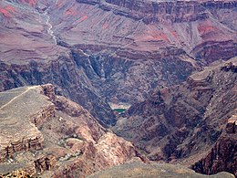
 Cardenas Basalt and Dox Formation of the Unkar Group Reddish Dox Formation below blackish Cardenas Basalt, upstream from Tanner Graben | |
| Type | Geologic group |
| Unit of | Grand Canyon Supergroup |
| Sub-units | Cardenas Basalt Dox Formation Shinumo Quartzite volcanic dikes as source for Cardenas Basalt Hakatai Shale Bass Formation |
| Underlies | Nankoweap Formation and, as part of the Great Unconformity, the Tapeats Sandstone |
| Overlies | Vishnu Basement Rocks |
| Area | Arizona, east Grand Canyon, Lava Butte region, on Colorado River, near Lipan Point |
| Thickness | 1,600 to 2,200 meters (5,200 to 7,200 ft) |
| Lithology | |
| Primary | sandstone, siltstone, shale, and basaltic volcanic rocks |
| Other | dolomite and limestone |
| Location | |
| Region | Arizona northcentral AZ into southcentral Utah in the subsurface |
| Country | Southwestern United States |
| Type section | |
| Named for | Unkar Valley |
| Named by | Walcott (1894)[1] and Noble (1910, 1914)[2][3] |

The Unkar Group is a sequence of strata of Proterozoic age that are subdivided into five geologic formations and exposed within the Grand Canyon, Arizona, Southwestern United States. The Unkar Group is the basal formation of the Grand Canyon Supergroup. The Unkar is about 1,600 to 2,200 m (5,200 to 7,200 ft) thick and composed, in ascending order, of the Bass Formation, Hakatai Shale, Shinumo Quartzite, Dox Formation, and Cardenas Basalt. The Cardenas Basalt and Dox Formation are found mostly in the eastern region of Grand Canyon. The Shinumo Quartzite, Hakatai Shale, and Bass Formation are found in central Grand Canyon. The Unkar Group accumulated approximately between 1250 and 1104 Ma (1,104 million years ago, 1.1 billion). In ascending order, the Unkar Group is overlain by the Nankoweap Formation, about 113 to 150 m (371 to 492 ft) thick; the Chuar Group, about 1,900 m (6,200 ft) thick; and the Sixtymile Formation, about 60 m (200 ft) thick. These are all of the units of the Grand Canyon Supergroup.[5][6][7] The Unkar Group makes up approximately half of the thickness of the Grand Canyon Supergroup.
In general, the strata comprising the Unkar Group dip northeast (10°–30°) toward normal faults that dip 60+° toward the southwest. This can be seen at the Palisades fault in the eastern part of the main Unkar Group outcrop area (below East Rim).
Within the central Grand Canyon, Unkar strata occur in small, rotated, downfaulted blocks or slivers where they commonly are only partially exposed. Within this center part of the Grand Canyon, the Unkar Group is incomplete because pre-Tonto Group erosion has removed strata above the level of the middle part of the Dox Formation. The missing part of the Unkar Group and the remainder of the overlying Grand Canyon Supergroup are preserved in a prominent syncline and fault block that is exposed in the eastern Grand Canyon. Examples of these fault blocks can be seen at the Isis Temple prominence, "Cheops Pyramid," and the intersection of Phantom Creek with the Bright Angel Canyon, (North Kaibab Trail). The Unkar Group also contains thick basaltic sills and a number of small, dark dikes. In the area of Desert View and west of Palisades of the Desert, the basaltic sills form very prominent, dark gray cliffs.[5][6][8]
Using gravity and aeromagnetic data, combined with gravity modeling, it was inferred that Proterozoic grabens, and half-grabens filled with strata of the Unkar Group – lie buried beneath Phanerozoic rocks in northern Arizona that surround the Grand Canyon. The grabens and half grabens filled with strata of the Unkar group are associated with northwest–southeast trending Mesoproterozoic fault systems that have curving, southwest-dipping traces. These fault systems were later reactivated during the Neoproterozoic, to form basins in which the following Chuar Group accumulated, and during the Cenozoic, to form geologic structures, i.e., faults, anticlines, synclines, and monoclines, that are exposed at the surface.[9]

Major unconformities separate the Unkar Group from the strata overlying and underlying it. First, the Unkar Group, as the bottom unit of the Grand Canyon Supergroup, lies directly upon deeply eroded granites, gneisses, pegmatites, and schists that comprise Vishnu Basement Rocks. Second, an angular unconformity, with a dip of less than 10°, separates the base of the Nankoweap Formation from the underlying Unkar Group. Finally, a well-defined angular unconformity at the base of the relatively flat-lying Tonto Group separates it from the underlying faulted and folded strata of the Unkar Group and the rest of the Grand Canyon Supergroup that are typically tilted at angles of 10°–30°.[5][6]

(expandable high-resolution photo)
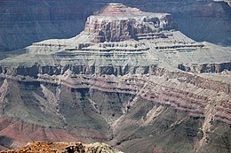
The western section of the Unkar group can be highlighted in a photo of three Unkar units below Isis Temple sitting on Vishnu Basement Rocks of Granite Gorge.
- ^ Walcott, CD (1894) Precambrian igneous rocks of the Unkar terrane, Grand Canyon of the Colorado. 14th Annual Report for 1892/3, part 2, pp. 492–519, United States Geological Survey, Reston, Virginia.
- ^ Noble, LF (1910) Contributions to the geology of the Grand Canyon, Arizona; the geology of the Shinumo area (continued). American Journal of Science. Series 4, vol. 29, pp. 497–528.
- ^ Noble, LF (1914) The Shinumo quadrangle, Grand Canyon district, Arizona. Bulletin no. 549, US Geological Survey, Reston, Virginia.
- ^ Karlstrom, K., Crossey, L., Mathis, A., and Bowman, C., 2021. Telling time at Grand Canyon National Park: 2020 update. Natural Resource Report NPS/GRCA/NRR—2021/2246. National Park Service, Fort Collins, Colorado. 36 pp.
- ^ a b c Hendricks, JD, and GM Stevenson (2003) Grand Canyon Supergroup: Unkar Group. In SS Beus and M Morales, eds., pp. 39–52, Grand Canyon Geology, 2nd ed. Oxford University Press, New York.
- ^ a b c Elston, DP (1989) Middle and late Proterozoic Grand Canyon Supergroup, Arizona. In DP Elston, GH Billingsley, and RA Young, RA., eds., pp. 94–105, Geology of the Grand Canyon, Northern Arizona (with Colorado River Guides). American Geophysical Union Fieldtrip Guidebook T115/315 for International Geologic Congress, 28th. American Geophysical Union, Washington DC. 239 pp.
- ^ Timmons, JM, J. Bloch, K. Fletcher, KE Karlstrom, M Heizler, and LJ Crossey (2012) The Grand Canyon Unkar Group: Mesoproterozoic basin formation in the continental interior during supercontinent assembly. In JM Timmons and KE Karlstrom, eds., pp. 25–47, Grand Canyon geology: Two billion years of earth's history. Special Paper no 294, Geological Society of America, Boulder, Colorado.
- ^ Lucchitta, I (2001) Hiking Arizona's Geology. Mountaineers's Books. (ISBN 0-89886-730-4)
- ^ Seeley, JM, and KG Randy (2003) Delineation of subsurface Proterozoic Unkar and Chuar Group sedimentary basins in northern Arizona using gravity and magnetics., implications for hydrocarbon source potential. American Association of Petroleum Geologists Bulletin. 87(8): 1299–1321.