Unorganized North Algoma District | |
|---|---|
| Algoma, Unorganized, North Part | |
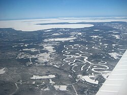
 An aerial view of Goulais River. | |
 | |
| Coordinates: 47°30′N 84°15′W / 47.500°N 84.250°W | |
| Country | Canada |
| Province | Ontario |
| District | Algoma |
| Government | |
| • MPs | Carol Hughes (NDP) Terry Sheehan (Liberal) |
| • MPP | Michael Mantha (NDP) |
| Area | |
| • Land | 44,077.03 km2 (17,018.24 sq mi) |
| Population (2021) | |
| • Total | 6,050 |
| • Density | 0.1/km2 (0.3/sq mi) |
| Time zone | UTC-5 (EST) |
| • Summer (DST) | UTC-4 (EDT) |
| Postal code span | P0L, P0M, P0R |
| Area code | 705 |
Unorganized North Algoma District is an unorganized area in northeastern Ontario, Canada, comprising all areas in Algoma District, north of the Sault Ste. Marie to Elliot Lake corridor, which are not part of an incorporated municipality or a First Nation. It covers 44,077.03 km2 (17,018.24 sq mi) of land, and had a population of 6050 in 2021.[2] Many of these communities were/are stations on the Algoma Central Railway or were logging/mining towns.
- ^ "Algoma, Unorganized, North Part census profile". 2016 Census of Population. Statistics Canada. Retrieved 2018-02-26.
- ^ Government of Canada, Statistics Canada (2022-02-09). "Data table, Census Profile, 2021 Census of Population - Algoma, Unorganized, North Part, Unorganized (NO) [Census subdivision], Ontario". www12.statcan.gc.ca. Retrieved 2022-04-16.