Unorganized Thunder Bay | |
|---|---|
| Thunder Bay, Unorganized | |
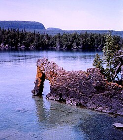
 Sleeping Giant Provincial Park | |
 | |
| Coordinates: 50°00′N 88°00′W / 50.000°N 88.000°W | |
| Country | Canada |
| Province | Ontario |
| District | Thunder Bay |
| Government | |
| • Federal riding | Algoma—Manitoulin—Kapuskasing Kenora Thunder Bay—Rainy River Thunder Bay—Superior North |
| • Prov. riding | Algoma—Manitoulin Kenora—Rainy River Thunder Bay—Atikokan Thunder Bay—Superior North |
| Area | |
| • Land | 97,009.80 km2 (37,455.69 sq mi) |
| Population (2016)[1] | |
• Total | 5,872 |
| • Density | 0.1/km2 (0.3/sq mi) |
| Time zones | |
| East of 90° west | UTC-05:00 (Eastern) |
| • Summer (DST) | UTC-04:00 (EDT) |
| West of 90° west | UTC-06:00 (Central) |
| • Summer (DST) | UTC-05:00 (CDT) |
| Postal Code FSA | P0T |
| Area code | 807 |
Unorganized Thunder Bay District is an unorganized area in northwestern Ontario, Canada in Thunder Bay District. It comprises all parts of the district that are not part of an incorporated municipality or a First Nations reserve.
Most of the territory is within the Eastern Time Zone, but the part west of the 90th meridian is in the Central Time Zone.
- ^ a b "Unorganized Thunder Bay District (Code 3558090) Census Profile". 2016 census. Government of Canada - Statistics Canada.