Upper Arlington, Ohio | |
|---|---|
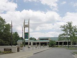
 The Upper Arlington Municipal Services Center | |
| Motto(s): | |
 Interactive map of the city | |
| Coordinates: 40°1′14″N 83°3′59″W / 40.02056°N 83.06639°W | |
| Country | United States |
| State | Ohio |
| County | Franklin |
| Area | |
• Total | 9.82 sq mi (25.45 km2) |
| • Land | 9.79 sq mi (25.37 km2) |
| • Water | 0.03 sq mi (0.08 km2) |
| Elevation | 814 ft (248 m) |
| Population (2020) | |
• Total | 36,800 |
| • Density | 3,757.02/sq mi (1,450.53/km2) |
| Time zone | UTC-5 (Eastern (EST)) |
| • Summer (DST) | UTC-4 (EDT) |
| Area code(s) | 614 and 380 |
| FIPS code | 39-79002 |
| GNIS feature ID | 1075125[2] |
| Website | https://upperarlingtonoh.gov/ |
Upper Arlington (often known by its initials U.A.) is a city in Franklin County, Ohio, United States, on the northwest side of the Columbus metropolitan area. As of the 2020 census, the population was 36,800. The Old Arlington neighborhood is listed on the National Register of Historic Places.
- ^ "ArcGIS REST Services Directory". United States Census Bureau. Retrieved September 20, 2022.
- ^ a b "US Board on Geographic Names". United States Geological Survey. October 25, 2007. Retrieved January 31, 2008.
