DT34
Upper Changi 樟宜上段 அப்பர் சாங்கி | |||||||||||
|---|---|---|---|---|---|---|---|---|---|---|---|
| Mass Rapid Transit (MRT) station | |||||||||||
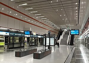
 Platform level of Upper Changi station | |||||||||||
| General information | |||||||||||
| Location | 690 Upper Changi Road East Singapore 485990[1][2] | ||||||||||
| Coordinates | 1°20′31″N 103°57′41″E / 1.3419°N 103.9614°E | ||||||||||
| Owned by | Land Transport Authority | ||||||||||
| Operated by | SBS Transit DTL (ComfortDelGro Corporation) | ||||||||||
| Line(s) | |||||||||||
| Platforms | 2 (1 island platform) | ||||||||||
| Tracks | 2 | ||||||||||
| Connections | Bus, Taxi | ||||||||||
| Construction | |||||||||||
| Structure type | Underground | ||||||||||
| Platform levels | 1 | ||||||||||
| Accessible | Yes | ||||||||||
| History | |||||||||||
| Opened | 21 October 2017 | ||||||||||
| Electrified | Yes | ||||||||||
| Previous names | Somapah[3][4] | ||||||||||
| Passengers | |||||||||||
| June 2024 | 4,562 per day[5] | ||||||||||
| Services | |||||||||||
| |||||||||||
| |||||||||||
Upper Changi MRT station is an underground Mass Rapid Transit station on the Downtown Line in Tampines planning area, Singapore, located under Upper Changi Road East.
The station serves residential estates in the vicinity and the campus of the Singapore University of Technology and Design, which is linked via an underground linkway. The station, along with Fort Canning, is one of the longest stations along the line, at 205 meters.
- ^ "Upper Changi MRT Station (DT34)". OneMap. Singapore Land Authority. Archived from the original on 7 March 2021. Retrieved 7 March 2021.
- ^ "Location View of 690 Upper Changi Road East, 485990". www.streetdirectory.com. Archived from the original on 7 March 2021. Retrieved 24 April 2020.
- ^ "Downtown Line 3 Station Names Shortlisted for Public Polling". www.lta.gov.sg. 1 June 2011. Archived from the original on 25 April 2016.
- ^ "Downtown Line 3 Station Names Finalised". www.lta.gov.sg. 19 August 2011. Archived from the original on 31 December 2013.
- ^ "Land Transport DataMall". Datamall. Land Transport Authority. Archived from the original on 14 August 2024. Retrieved 14 August 2024.
