Upper Fairfield Township, Lycoming County, Pennsylvania | |
|---|---|
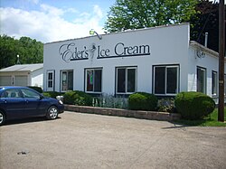
 Eder's Ice Cream in Upper Fairfield Township | |
 Map of Lycoming County, Pennsylvania highlighting Upper Fairfield Township | |
 Map of Lycoming County, Pennsylvania | |
| Coordinates: 41°19′10″N 76°51′41″W / 41.31944°N 76.86139°W | |
| Country | United States |
| State | Pennsylvania |
| County | Lycoming |
| Settled | 1800 |
| Incorporated | 1851 |
| Area | |
• Total | 18.12 sq mi (46.93 km2) |
| • Land | 17.96 sq mi (46.52 km2) |
| • Water | 0.15 sq mi (0.40 km2) |
| Elevation | 896 ft (273 m) |
| Population | |
• Total | 1,807 |
• Estimate (2021)[3] | 1,801 |
| • Density | 100.48/sq mi (38.80/km2) |
| Time zone | UTC-5 (Eastern (EST)) |
| • Summer (DST) | UTC-4 (EDT) |
| FIPS code | 42-081-79024 |
| GNIS feature ID | 1216774[2] |
| Website | upperfairfieldtwp |
Upper Fairfield Township is a township in Lycoming County, Pennsylvania, United States. The population was 1,807 at the 2020 census.[3] It is part of the Williamsport Metropolitan Statistical Area.
- ^ "2016 U.S. Gazetteer Files". United States Census Bureau. Retrieved Aug 14, 2017.
- ^ a b "US Board on Geographic Names". United States Geological Survey. 2007-10-25. Retrieved 2008-01-31.
- ^ a b c Bureau, US Census. "City and Town Population Totals: 2020-2021". Census.gov. US Census Bureau. Retrieved 15 July 2022.
{{cite web}}:|last1=has generic name (help)