Upper Hanover Township | |
|---|---|
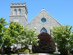
 Palm Schwenkfelder Church (1910). Palm. | |
 Location of Upper Hanover Township in Montgomery County | |
| Coordinates: 40°22′00″N 75°29′35″W / 40.36667°N 75.49306°W | |
| Country | United States |
| State | Pennsylvania |
| County | Montgomery |
| Area | |
• Total | 21.17 sq mi (54.8 km2) |
| • Land | 20.24 sq mi (52.4 km2) |
| • Water | 0.94 sq mi (2.4 km2) |
| Elevation | 381 ft (116 m) |
| Population (2010) | |
• Total | 6,464 |
• Estimate (2016)[2] | 7,465 |
| • Density | 310/sq mi (120/km2) |
| Time zone | UTC-5 (EST) |
| • Summer (DST) | UTC-4 (EDT) |
| ZIP codes | 18041, 18070, 18073, 18076, 19504 |
| Area code(s) | 215, 267, and 445 |
| FIPS code | 42-091-79064 |
| Website | www |
Upper Hanover Township is a township in Montgomery County, Pennsylvania, United States. The population was 6,464 at the 2010 census.
It is part of the Upper Perkiomen School District.
- ^ "2016 U.S. Gazetteer Files". United States Census Bureau. Retrieved August 14, 2017.
- ^ "Population and Housing Unit Estimates". Retrieved June 9, 2017.