Upper Uwchlan Township | |
|---|---|
 Upper Uwchlan Township in October 2015 | |
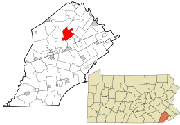
 Location of Upper Uwchlan Township in Chester County, Pennsylvania (top) and of Chester County in Pennsylvania (below) | |
 Location of Pennsylvania in the United States | |
| Coordinates: 40°05′18″N 75°41′58″W / 40.08833°N 75.69944°W | |
| Country | United States |
| State | Pennsylvania |
| County | Chester |
| Area | |
| • Total | 11.72 sq mi (30.36 km2) |
| • Land | 10.89 sq mi (28.21 km2) |
| • Water | 0.83 sq mi (2.15 km2) |
| Elevation | 469 ft (143 m) |
| Population (2010) | |
| • Total | 11,227 |
| • Estimate (2016)[2] | 11,500 |
| • Density | 1,055.72/sq mi (407.60/km2) |
| Time zone | UTC-5 (EST) |
| • Summer (DST) | UTC-4 (EDT) |
| ZIP Code | 19480 |
| Area code(s) | 484, 610, 835 |
| FIPS code | 42-029-79352 |
| Website | www |
Upper Uwchlan Township (/ˈjuːklən/; [ˈɪuxlan]) is a township in Chester County, Pennsylvania, United States. The population was 11,227 at the 2010 census. The township included the community of Milford Mills before it was inundated by the creation of the Marsh Creek Dam in 1972.
The main population center of the township has grown surrounding the historic Eagle Tavern at the intersection of Route 100 and Little Conestoga Road. This major unincorporated community is known as the village of Eagle, but also sometimes known as Uwchlan. That is the address of the local post office.
- ^ "2016 U.S. Gazetteer Files". United States Census Bureau. Retrieved August 13, 2017.
- ^ "Population and Housing Unit Estimates". Retrieved June 9, 2017.