| Upton State Forest | |
|---|---|
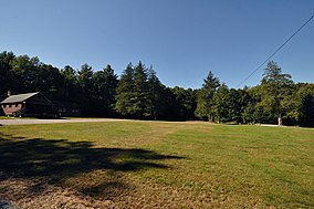
 Parade ground of the former CCC camp area | |
| Location | Upton, Hopkinton, Westborough, Worcester, Middlesex, Massachusetts, United States |
| Coordinates | 42°12′33″N 71°36′29″W / 42.20917°N 71.60806°W |
| Area | 2,790 acres (11.3 km2)[1] |
| Elevation | 502 ft (153 m)[2] |
| Established | 1915[3] |
| Operator | Massachusetts Department of Conservation and Recreation |
| Website | Upton State Forest |
Upton State Forest is a publicly owned forest with recreational features primarily located in the town of Upton, Massachusetts, with smaller sections in the towns of Hopkinton and Westborough. The state forest encompasses nearly 2,800 acres (1,100 ha) of publicly accessible lands and includes the last remaining Civilian Conservation Corps (CCC) camp in Massachusetts, built in Rustic style.[4] The CCC campground was listed on the National Register of Historic Places in 2014.[5][6]
- ^ Cite error: The named reference
2012acreagelistwas invoked but never defined (see the help page). - ^ "Upton State Forest". Geographic Names Information System. United States Geological Survey, United States Department of the Interior.
- ^ Cite error: The named reference
gaskillwas invoked but never defined (see the help page). - ^ Cite error: The named reference
nominationwas invoked but never defined (see the help page). - ^ Cite error: The named reference
dcrwas invoked but never defined (see the help page). - ^ Cite error: The named reference
listingwas invoked but never defined (see the help page).

