Uptown | |
|---|---|
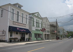
 Local businesses on Prytania Street | |
 | |
| Coordinates: 29°55′34″N 90°06′28″W / 29.92611°N 90.10778°W | |
| Country | United States |
| State | Louisiana |
| City | New Orleans |
| Planning District | District 3, Uptown/Carrollton |
| Area | |
• Total | 0.64 sq mi (1.7 km2) |
| • Land | 0.64 sq mi (1.7 km2) |
| • Water | 0.00 sq mi (0.0 km2) |
| Elevation | 2 ft (0.6 m) |
| Population (2010) | |
• Total | 3,201 |
| • Density | 5,000/sq mi (1,900/km2) |
| Time zone | UTC-6 (CST) |
| • Summer (DST) | UTC-5 (CDT) |
| Area code | 504 |
Uptown is a primarily residential neighborhood of the city of New Orleans. A subdistrict of the Uptown/Carrollton Area, its boundaries as defined by the New Orleans City Planning Commission are: LaSalle Street to the north, Napoleon Avenue to the east, Magazine Street to the south and Jefferson Avenue to the west.