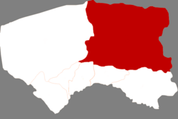
Urad Middle Banner
乌拉特中旗 • ᠤᠷᠠᠳ ᠤᠨ ᠳᠤᠮᠳᠠᠳᠤ ᠬᠣᠰᠢᠭᠤ | |
|---|---|
 Urad Middle Banner in Bayannur | |
| Coordinates: 41°34′N 108°32′E / 41.567°N 108.533°E | |
| Country | China |
| Autonomous region | Inner Mongolia |
| Prefecture-level city | Bayannur |
| Banner seat | Haliut |
| Area | |
• Total | 22,820 km2 (8,810 sq mi) |
| Population (2020)[1] | |
• Total | 112,159 |
| • Density | 4.9/km2 (13/sq mi) |
| Time zone | UTC+8 (China Standard) |
| Website | www |
| Urad Middle Banner | |||||||
|---|---|---|---|---|---|---|---|
| Chinese name | |||||||
| Simplified Chinese | 乌拉特中旗 | ||||||
| Traditional Chinese | 烏拉特中旗 | ||||||
| |||||||
| Mongolian name | |||||||
| Mongolian Cyrillic | Урадын дундад хошуу | ||||||
| Mongolian script | ᠤᠷᠠᠳ ᠤᠨ ᠳᠤᠮᠳᠠᠳᠤ ᠬᠣᠰᠢᠭᠤ | ||||||
| |||||||
Urad Middle Banner (Mongolian: ᠤᠷᠠᠳ ᠤᠨ ᠳᠤᠮᠳᠠᠳᠤ ᠬᠣᠰᠢᠭᠤ; Chinese: 乌拉特中旗) is a banner of Inner Mongolia, China. It is located in the west of the region, and administratively is part of Bayan Nur City. It has a total area of 22,606 square kilometres (8,728 sq mi) and in 2020 had a population of 112,159.

