Urad Rear Banner
乌拉特后旗 · ᠤᠷᠠᠳ ᠤᠨ ᠬᠣᠶᠢᠲᠤ ᠬᠣᠰᠢᠭᠤ | |
|---|---|
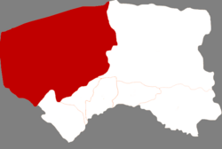
 Urat Rear Banner in Bayannur | |
 Bayannur in Inner Mongolia | |
| Coordinates: 41°04′53″N 107°04′17″E / 41.0815°N 107.0715°E | |
| Country | China |
| Autonomous region | Inner Mongolia |
| Prefecture-level city | Bayannur |
| Banner seat | Bayan Bulag |
| Area | |
| • Total | 24,530 km2 (9,470 sq mi) |
| Population (2020)[1] | |
| • Total | 53,946 |
| • Density | 2.2/km2 (5.7/sq mi) |
| Time zone | UTC+8 (China Standard) |
| Website | www |
| Urad Rear Banner | |||||||
|---|---|---|---|---|---|---|---|
| Chinese name | |||||||
| Simplified Chinese | 乌拉特后旗 | ||||||
| Traditional Chinese | 烏拉特後旗 | ||||||
| |||||||
| Mongolian name | |||||||
| Mongolian Cyrillic | Урадын хойд хошуу | ||||||
| Mongolian script | ᠤᠷᠠᠳ ᠤᠨ ᠬᠣᠶᠢᠲᠤ ᠬᠣᠰᠢᠭᠤ | ||||||
| |||||||
Urad Rear Banner (Mongolian: ᠤᠷᠠᠳ ᠤᠨ ᠬᠣᠶᠢᠲᠤ ᠬᠣᠰᠢᠭᠤ; Chinese: 乌拉特后旗) is a banner of the Inner Mongolia Autonomous Region, China. It is located in the west of the region, 44 kilometres (27 mi) northwest of the city of Bayan Nur, which administers this banner, and borders the Republic of Mongolia's Ömnögovi Province to the north. The banner has a total area of 24,925 km2 (9,624 sq mi) and in 2020 had a population of 53,946. It is located in the prefectural-level municipality of Bayannur city. The capital is moved to the town of Bayan Bulag. This Banner division is also home[2] to the Upper Cretaceous Bayan Mandahu Formation.

