Montreal
Montréal | |
|---|---|
 | |
| Coordinates: 45°30′N 73°34′W / 45.500°N 73.567°W | |
| Country | |
| Province | |
| Government | |
| • Mayor | Valérie Plante |
| • President of Executive Committee | Nancy Blanchet |
| Area | |
| • Land | 498.29 km2 (192.39 sq mi) |
| Population (2021)[1] | |
| • Total | 2,004,265 |
| • Density | 4,022.3/km2 (10,418/sq mi) |
| Demonym | Montrealer/Montréalais(e) |
| Time zone | UTC-5 (EST) |
| • Summer (DST) | UTC-4 (EDT) |
| Postal code | |
| Area code | 514 and 438 |
| Website | Agglomeration council |
| [2] | |
The urban agglomeration of Montreal (French: agglomération de Montréal) is an urban agglomeration in Quebec, Canada. Coextensive with the administrative region of Montreal, it is a territory equivalent to a regional county municipality (TE) and a census division (CD), for both of which its geographical code is 66. Prior to the merger of the municipalities in Region 06 in 2002, the administrative region was co-extensive with the Montreal Urban Community.
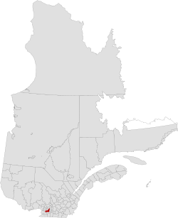
Located in the southern part of the province, the territory includes several of the islands of the Hochelaga Archipelago in the Saint Lawrence River, including the Island of Montreal, Nuns' Island (Île des Sœurs), Île Bizard, Saint Helen's Island (Île Sainte-Hélène), Île Notre-Dame, Dorval Island (Île Dorval), and several others. Only the first three of these islands are inhabited.
The region is the second-smallest in area (498.29 km2 (192.39 sq mi)) and most populous (2,004,265 as of the 2021 Canadian Census)[1] of Quebec's seventeen administrative regions.