This article needs additional citations for verification. (December 2007) |
Sudbury | |
|---|---|
Former city | |
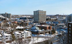
 Downtown Sudbury. | |
 | |
| Country | Canada |
| Province | Ontario |
| City | Greater Sudbury |
| Wards | 1, 2, 4, 5, 8, 9, 10, 11, 12 |
| Incorporated (Town) | 1893 |
| Incorporated (City) | 1930 |
| Dissolved | 2000 |
| Government | |
| • City Councillors | Mark Signoretti, Evelyn Dutrisac, Robert Kirwan, Al Sizer, Deb McIntosh, Fern Cormier, Lynne Reynolds, Joscelyne Landry-Altmann |
| • Governing Body | Greater Sudbury City Council |
| • MPs | Viviane Lapointe (Liberal) Marc Serré (Liberal) |
| • MPPs | France Gélinas (NDP) Jamie West (NDP) |
| Population (2001)Statistics Canada | |
• Total | 92,059 |
| Time zone | UTC-5 (EST) |
| • Summer (DST) | UTC-4 (EDT) |
| Postal Code FSA | P3A, P3B, P3C, P3E, P3G, P0M |
| Area code | 705 |
This is a list of neighbourhoods in the urban core of Greater Sudbury, Ontario. This list includes only those neighbourhoods that fall within the pre-2001 city limits of Sudbury — for communities within the former suburban municipalities, see the articles Capreol, Nickel Centre, Onaping Falls, Rayside-Balfour, Valley East and Walden.