| Urubamba River Vilcanota River | |
|---|---|
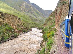
 Urubamba River seen from train en route to Machu Picchu | |
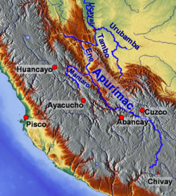
 Map of larger rivers in south-central Peru | |
| Location | |
| Country | Peru |
| Physical characteristics | |
| Mouth | Ucayali River |
• coordinates | 10°42′07″S 73°45′15″W / 10.70194°S 73.75417°W |
| Length | 724 km (450 mi)[1] |
| Basin features | |
| Tributaries | |
| • left | Lucumayo, Cusichaca, Kachimayu |
| • right | Chillcamayu, Yavero |

The Urubamba River or Vilcamayo River[2] (possibly from Quechua Willkamayu, for "sacred river")[3] is a river in Peru. Upstream it is called Vilcanota River (possibly from Aymara Willkanuta, for "house of the sun").[4] Within the La Convención Province, the name changes to Urubamba.[5] A partially navigable headwater of the Amazon River, the Urubamba rises in the Andes to the southeast of Cusco. It originates on the slopes of Cunurana in the Puno Region, Melgar Province, near the La Raya pass.[5] It flows north-north-west for 724 km (450 mi) before coalescing with the Tambo River to form the Ucayali River.
The Urubamba is divided into the Upper Urubamba and the Lower Urubamba, the dividing feature being the Pongo de Mainique, an infamous whitewater canyon, where the river narrows to a width of 45 metres (148 ft).
- ^ Cite error: The named reference
faowas invoked but never defined (see the help page). - ^ Cite error: The named reference
mintrawas invoked but never defined (see the help page). - ^ Cite error: The named reference
simiwas invoked but never defined (see the help page). - ^ Cite error: The named reference
bertoniowas invoked but never defined (see the help page). - ^ a b Cite error: The named reference
ambientewas invoked but never defined (see the help page).