| Utkinton | |
|---|---|
 Bailiff's House | |
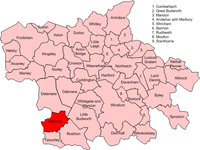
Location within Cheshire | |
| Population | 706 (2011 census) |
| Civil parish | |
| Unitary authority | |
| Ceremonial county | |
| Region | |
| Country | England |
| Sovereign state | United Kingdom |
| Post town | TARPORLEY |
| Postcode district | CW6 |
| Dialling code | 01829 |
| Police | Cheshire |
| Fire | Cheshire |
| Ambulance | North West |
| UK Parliament | |

Utkinton is a village and former civil parish, now in the parishes of Utkinton and Cotebrook, in the unitary authority area of Cheshire West and Chester and the ceremonial county of Cheshire, England. It is approximately 2 miles (3.2 km) north of Tarporley, 8 miles (13 km) west of Winsford and 9 miles (14 km) east of Chester. The upper part of Utkinton is known as 'Quarry Bank'. Utkinton is at the heart of the local farming community. The area is also on the Sandstone Trail.
At the time of the 2001 census the population of the parish was 651,[1] increasing to 706 by the 2011 census.[2]
- ^ UK Census (2001). "Local Area Report – Utkinton Parish (13UH039)". Nomis. Office for National Statistics. Retrieved 24 February 2021.
- ^ UK Census (2011). "Local Area Report – Utkinton Parish (E04011183)". Nomis. Office for National Statistics. Retrieved 24 February 2021.
