Uttara
উত্তরা | |
|---|---|
| Uttara Model Town | |
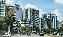
 Skyline of Uttara, Dhaka | |
| Nickname: A city within a city[1] | |
 | |
| Coordinates: 23°52′37″N 90°22′37″E / 23.877°N 90.377°E | |
| Country | |
| Division | Dhaka Division |
| District | Dhaka District |
| Metropolitan | DNCC |
| Establishment | 1966 |
| Founded by | RAJUK |
| Area | |
| • Total | 36.91 km2 (14.25 sq mi) |
| Elevation | 23 m (75 ft) |
| Population (2011) | |
| • Total | 179,907 |
| • Density | 4,874.20/km2 (12,624.1/sq mi) |
| Time zone | UTC+6 (BST) |
| Postal code | 1230 |
Uttara Model Town or simply Uttara (Bengali: উত্তরা romanised: Uttora) is a neighbourhood of Dhaka, the capital of Bangladesh. The name derives from the Bengali word uttor (Bengali: উত্তর) meaning "north". It lies on the road to Gazipur, and adjoins Hazrat Shahjalal International Airport.
- ^ https://www.thedailystar.net/business/news/uttara-city-within-city-3607126
- ^ "Geographic coordinates of Dhaka, Bangladesh". DATEANDTIME.INFO. Archived from the original on 10 August 2016. Retrieved 7 July 2016.

