| Vaal / ǀHai Lekwa, IliKwa | |
|---|---|
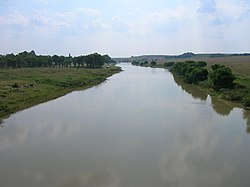
 The Vaal seen from the N3 national freeway, upstream from the Vaal Dam. Here it forms the border between the Mpumalanga and Free State provinces. | |
 | |
| Etymology | ǀHai "Pale" + ǃArib "River" |
| Native name | ǀHaiǃarib (Korana) |
| Location | |
| Country | South Africa |
| Region | Free State, Gauteng, Northern Cape, Mpumalanga |
| Physical characteristics | |
| Source | |
| • location | Near Breyten |
| Mouth | Orange River |
• location | Near Douglas |
• coordinates | 29°4′15″S 23°38′10″E / 29.07083°S 23.63611°E |
• elevation | 1,241 m (4,072 ft) |
| Length | 1,458 km (906 mi) |
| Basin size | 196,438 km2 (75,845 sq mi) |
| Discharge | |
| • location | Orange River |
| • average | 125 m3/s (4,400 cu ft/s) |
| Basin features | |
| Tributaries | |
| • left | Vet River |
The Vaal River (/ˈvɑːl/ Afrikaans pronunciation: [ˈfɑːl]; Khoemana: ǀHaiǃarib) is the largest tributary of the Orange River in South Africa. The river has its source near Breyten in Mpumalanga province, east of Johannesburg and about 30 kilometres (19 mi) north of Ermelo and only about 240 kilometres (150 mi) from the Indian Ocean.[1] It then flows westwards to its confluence with the Orange River southwest of Kimberley in the Northern Cape. It is 1,458 kilometres (906 mi) long, and forms the border between Mpumalanga, Gauteng and North West Province on its north bank, and the Free State on its south.
It is the third largest river in South Africa after the Orange River (2200 km long) and the Limpopo River (1750 km long) and was established as the main source of water for the great Witswatersrand area after the 19th century gold rush.[2] The Vaal Dam lies on the Vaal River in Deneysville just south of the border between Gauteng and the Free State. The Vaal River is the longest river wholly within the borders of South Africa.
Vaal is a Dutch name (later Afrikaans), translated by the Griquas or Boers[3] from an earlier Kora Khoekhoe or !Orakobab name, sometimes spelled as Tky-Gariep (in Khoekhoegowab orthography it is ǀHai!garib, drab river).[4] Both Vaal and Tky (in modern orthography ǀHai) mean "drab" or "dull", which alludes to the colour of the waters, especially noticeable during flood season when the river is laden with silt. In the upper reaches the river was named iLigwa (Sindebele), Ikwa or Igwa (isiZulu), ilikwa (siSwati), lekwa (Sesotho), or cuoa by the Khoikhoi, all referring to the plain it traverses.[4]
- ^ Times Comprehensive Atlas, 12th ed. Times Books, London, 2007
- ^ 9 longest rivers. SA9. Accessed 2 April 2018.
- ^ Thompson, G. (1827). Travels and Adventures in Southern Africa I. Henry Colburn, London. p. 74.
- ^ a b du Plessis, E.J. (1973). Suid-Afrikaanse berg- en riviername. Tafelberg-uitgewers, Cape Town. pp. 326, 221. ISBN 0-624-00273-X.
