This article contains too many pictures for its overall length. (November 2024) |
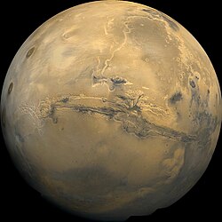
 Valles Marineris stretches over 4,000 km (2,500 mi) across Mars, mostly east-west just below the equator, as seen in this Viking 1 orbiter image mosaic. | |
| Feature type | Fault system |
|---|---|
| Coordinates | 13°54′S 59°12′W / 13.9°S 59.2°W |
| Length | over 4,000 km (2,500 mi) |
| Naming | Mariner 9 |
Valles Marineris (/ˈvælɪs mærɪˈnɛərɪs/;[1] Latin for Mariner Valleys, named after the Mariner 9 Mars orbiter of 1971–72 which discovered it) is a system of canyons that runs along the Martian surface east of the Tharsis region.[2] At more than 4,000 km (2,500 mi) long, 200 km (120 mi) wide and up to 7 km (23,000 ft) deep,[3][4] Valles Marineris is the largest canyon in the Solar System.[5]
Valles Marineris is located along the equator of Mars, on the east side of the Tharsis Bulge, and stretches for nearly a quarter of the planet's circumference. The canyon system starts in the west with Noctis Labyrinthus; proceeding to the east are Tithonium and Ius chasmata, then Melas, Candor and Ophir chasmata, then Coprates Chasma, then Ganges, Capri and Eos chasmata; finally it empties into an outflow channel region containing chaotic terrain that ends in the basin of Chryse Planitia.
It has been recently suggested that Valles Marineris is a large tectonic "crack" in the Martian crust.[6][7] Most researchers agree that this formed as the crust thickened in the Tharsis region to the west, and was subsequently widened by erosion. Near the eastern flanks of the rift, there appear to be channels that may have been formed by water or carbon dioxide. It has also been proposed that Valles Marineris is a large channel formed by the erosion of lava flowing from the flank of Pavonis Mons.[8]
- ^ "Valles Marineris". Dictionary.com Unabridged (Online). n.d.
- ^ "Valles Marineris". Gazetteer of Planetary Nomenclature. USGS Astrogeology Science Center. Retrieved 2015-02-28.
- ^ "Vallis Marineris". Goddard Space Flight Center. NASA. 2002. Archived from the original on 2007-07-11. Retrieved 2018-01-22.
- ^ "Valles Marineris". NASA. 2005. Retrieved 2018-01-22.
- ^ "Valles Marineris: The Grand Canyon of Mars". NASA. 2008-03-23. Retrieved 2024-01-25.
- ^ Wolpert, Stuart (2012-08-09). "UCLA scientist discovers plate tectonics on Mars". UCLA. Retrieved 2012-08-13.
- ^ Lin, An (2012-06-04). "Structural analysis of the Valles Marineris fault zone: Possible evidence for large-scale strike-slip faulting on Mars". Lithosphere. 4 (4): 286–330. Bibcode:2012Lsphe...4..286Y. doi:10.1130/L192.1.
- ^ Leone, Giovanni (2014-05-01). "A network of lava tubes as the origin of Labyrinthus Noctis and Valles Marineris on Mars". Journal of Volcanology and Geothermal Research. 277: 1–8. Bibcode:2014JVGR..277....1L. doi:10.1016/j.jvolgeores.2014.01.011.