Valley Hi, Ohio | |
|---|---|
 Mad River Mountain, with subdivisions in the hills above | |
 Location of Valley Hi, Ohio | |
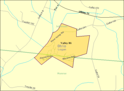
 Detailed map of Valley Hi | |
| Coordinates: 40°18′58″N 83°40′33″W / 40.31611°N 83.67583°W | |
| Country | United States |
| State | Ohio |
| County | Logan |
| Townships | Jefferson, Monroe |
| Area | |
| • Total | 0.62 sq mi (1.61 km2) |
| • Land | 0.62 sq mi (1.61 km2) |
| • Water | 0.00 sq mi (0.00 km2) |
| Elevation | 1,227 ft (374 m) |
| Population (2020) | |
| • Total | 228 |
| • Density | 366.56/sq mi (141.60/km2) |
| Time zone | UTC-5 (Eastern (EST)) |
| • Summer (DST) | UTC-4 (EDT) |
| FIPS code | 39-79226[3] |
| GNIS feature ID | 2400039[2] |
Valley Hi is a village in Logan County, Ohio, United States. The population was 228 at the 2020 census. The village is located nearby U.S. Route 33 and is about an hour northwest of Columbus. The village lies mostly in Jefferson Township, but its southernmost portion extends into Monroe Township.
- ^ "ArcGIS REST Services Directory". United States Census Bureau. Retrieved September 20, 2022.
- ^ a b U.S. Geological Survey Geographic Names Information System: Valley Hi, Ohio
- ^ "U.S. Census website". United States Census Bureau. Retrieved January 31, 2008.