Valmont, Colorado | |
|---|---|
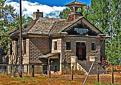
 Valmont School, built in 1911 (2010 photo) | |
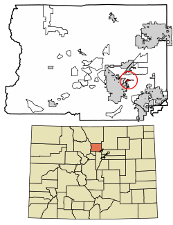
 Location of the Valmont CDP in Boulder County, Colorado | |
Location of the Valmont CDP in the United States | |
| Coordinates: 40°02′03″N 105°12′23″W / 40.03417°N 105.20639°W[1] | |
| Country | |
| State | |
| County | Boulder County |
| Platted | 1865 |
| Government | |
| • Type | unincorporated community |
| Area | |
• Total | 0.912 km2 (0.352 sq mi) |
| • Land | 0.698 km2 (0.269 sq mi) |
| • Water | 0.214 km2 (0.083 sq mi) |
| Elevation | 1,573 m (5,161 ft) |
| Population | |
• Total | 64 |
| • Density | 70/km2 (180/sq mi) |
| Time zone | UTC-7 (MST) |
| • Summer (DST) | UTC-6 (MDT) |
| ZIP Code[4] | Boulder 80301 |
| Area codes | 303 & 720 |
| GNIS feature ID | 2583311[1] |
Valmont is an unincorporated community and a census-designated place (CDP) located in and governed by Boulder County, Colorado, United States. The CDP is a part of the Boulder, CO Metropolitan Statistical Area. The population of the Valmont CDP was 64 at the United States Census 2020.[3] The land use consists of farming, low-density residential, some commercial, and a few school and church properties. The Boulder post office (Zip Code 80301) serves the area.[4]
- ^ a b c d U.S. Geological Survey Geographic Names Information System: Valmont, Colorado
- ^ "State of Colorado Census Designated Places - BAS20 - Data as of January 1, 2020". United States Census Bureau. Retrieved December 12, 2020.
- ^ a b United States Census Bureau. "Valmont CDP, Colorado". Retrieved April 17, 2023.
- ^ a b "Zip Code 80301 Map and Profile". zipdatamaps.com. 2020. Retrieved December 20, 2020.
