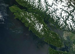
 Terra satellite image of Vancouver Island, 2003 | |
 Vancouver Island with major cities and towns labelled | |
| Geography | |
|---|---|
| Location | North Pacific Ocean, on the coast of southern British Columbia |
| Coordinates | 49°36′N 125°30′W / 49.6°N 125.5°W |
| Area | 32,100 km2 (12,400 sq mi) |
| Area rank | 11th largest in Canada 43rd largest worldwide |
| Highest elevation | 2,195 m (7201 ft) |
| Highest point | Golden Hinde[1] |
| Administration | |
Canada | |
| Province | British Columbia |
| Largest settlement | Saanich (pop. 117,735, part of Greater Victoria, 397,237[2]) |
| Demographics | |
| Demonym | Vancouver Islander |
| Population | 864,864[3] (2021) |
| Pop. density | 27.64/km2 (71.59/sq mi) |
Vancouver Island is an island in the northeastern Pacific Ocean and part of the Canadian province of British Columbia. The island is 456 km (283 mi) in length, 100 km (62 mi) in width at its widest point,[4] and 32,100 km2 (12,400 sq mi) in total area, while 31,285 km2 (12,079 sq mi) are of land. The island is the largest by area and the most populous along the west coasts of the Americas.
The southern part of Vancouver Island and some of the nearby Gulf Islands are the only parts of British Columbia or Western Canada to lie south of the 49th parallel. The southeast part of the island has one of the warmest climates in Canada, and since the mid-1990s has been mild enough in a few areas to grow Mediterranean crops such as olives and lemons.[5]
The population of Vancouver Island was 864,864 as of 2021.[3] Nearly half of that population (~400,000) live in the metropolitan area of Greater Victoria on the southern tip of the island, which includes Victoria, the capital of British Columbia. Other notable cities and towns on Vancouver Island include Nanaimo, Campbell River, Courtenay, Port Alberni and Parksville, all on or near the east coast.
Indigenous peoples have inhabited Vancouver Island for thousands of years,[6] long before the arrival of Spanish and British naval expeditions in the late 18th century. The Spanish and British conjointly named it Quadra's and Vancouver's Island in commemoration of the friendly negotiations held in 1792 between the Spanish commander of Fort San Miguel in Nootka Sound, Juan Francisco de la Bodega y Quadra, and British naval captain George Vancouver, during the Nootka Crisis. (Bodega y Quadra's name was eventually dropped.) It is one of several North American locations named after George Vancouver, who between 1791 and 1794 explored the Pacific Northwest.
Vancouver Island is the world's 43rd largest island, Canada's 11th largest island, and Canada's second most populous island after the Island of Montreal.
- ^ "BC Parks – Strathcona Provincial Park, Central Vancouver Island, British Columbia". Archived from the original on 2011-09-27. Retrieved 2010-09-16.
- ^ "Saanich, BC Census Profile". Archived from the original on 2017-02-11. Retrieved 2014-11-12.
- ^ a b [1] Archived 2022-02-22 at the Wayback Machine 2021 Canada Census. Retrieved 2022-02-21.
- ^ "Regional Geography – Vancouver Island, BC – Destination BC – Official Site". Hellobc.com. Archived from the original on 8 August 2017. Retrieved 8 January 2018.
- ^ "Milder winters allow growth of lemons and olives on Vancouver Island". The Globe and Mail. Archived from the original on 1 July 2015. Retrieved 8 January 2018.
- ^ Cite error: The named reference
Heritage2007was invoked but never defined (see the help page).