| Vancouver Island Ranges | |
|---|---|
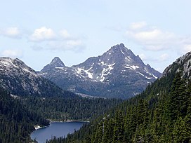
 Golden Hinde, south aspect, August 2006. | |
| Highest point | |
| Peak | Golden Hinde |
| Elevation | 2,195 m (7,201 ft) |
| Coordinates | 49°39′43.8″N 125°44′48.6″W / 49.662167°N 125.746833°W |
| Dimensions | |
| Area | 45,373 km2 (17,519 sq mi) |
| Geography | |
 | |
| Country | Canada |
| Province | British Columbia |
| Range coordinates | 49°40′N 125°49′W / 49.667°N 125.817°W |
| Parent range | Insular Mountains |
The Vancouver Island Ranges, formerly called the Vancouver Island Mountains, are a series of mountain ranges extending along the length of Vancouver Island which has an area of 31,788 km2 (12,273 sq mi). The Vancouver Island Ranges comprise the central and largest part of the island.[1] The Geological Survey of Canada refers to Vancouver Island, Haida Gwaii, and the Alaska Panhandle as the Insular Belt including the sea floor out to 100 km (62 mi) west of Vancouver Island.[2] The Vancouver Island Ranges are a sub-range of the Insular Mountains.
- ^ Guthrie, R.H. (2005). Geomorthology of Vancouver Island: Mass Wasting Potential (Report). BC Ministry of Environment. doi:10.13140/RG.2.1.3032.9848. p 1 (and see map at p 2 for area of Vancouver Island Ranges) ISBN 0-7726-5468-9
- ^ "Geodetic Survey of Canada, Cordilleran Geoscience Island mountains and sea floor". Archived from the original on 2006-10-20. Retrieved 2006-10-16.