Vanport, Oregon | |
|---|---|
Former city destroyed by flood | |
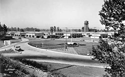
 Vanport in 1943, five years before the flood | |
| Coordinates: 45°36′07″N 122°42′00″W / 45.60194°N 122.70000°W | |
| Country | United States |
| State | Oregon |
| County | Multnomah |
| Elevation | 23 ft (7 m) |
| Time zone | UTC-8 (Pacific) |
| • Summer (DST) | UTC-7 (Pacific) |
| GNIS feature ID | 1128512[1] |
Vanport, sometimes referred to as Vanport City or Kaiserville,[1] was a city of wartime public housing in Multnomah County, Oregon, United States, between the contemporary Portland city boundary and the Columbia River. It was destroyed in the 1948 Columbia River flood and not rebuilt. It sat on what is currently the site of Delta Park and the Portland International Raceway.[2]
- ^ a b c "Vanport City (historical)". Geographic Names Information System. United States Geological Survey. November 28, 1980. Retrieved June 21, 2014.
- ^ "East Delta Park". Portland Parks & Recreation. Retrieved December 19, 2006.
