| Varangerfjorden | |
|---|---|
| |
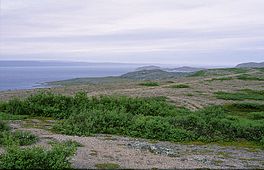
 View of the fjord | |
 Interactive map of the fjord | |
| Location | Finnmark county, Norway |
| Coordinates | 70°05′28″N 31°00′33″E / 70.0911°N 31.0091°E |
| Type | Fjord |
| Primary outflows | Barents Sea |
| Ocean/sea sources | Barents Sea |
| Basin countries | Norway |
| Max. length | 100 kilometres (62 mi) |
| Max. width | 70 kilometres (43 mi) |
| Settlements | Vardø, Vadsø |
The Varangerfjord (English: Varanger Fjord;[1][2][3] Russian: Варангер-фьорд, Варяжский залив; Finnish: Varanginvuono; Northern Sami: Várjavuonna) is the easternmost fjord in Norway, north of Finland. The fjord is located in Finnmark county between the Varanger Peninsula and the mainland of Norway. The fjord flows through the municipalities of Vardø, Vadsø, Nesseby, and Sør-Varanger. The fjord is approximately 100 kilometres (62 mi) long, emptying into the Barents Sea. In a strict sense, it is a false fjord, since it does not have the hallmarks of a fjord carved by glaciers.
Its mouth is about 70 kilometres (43 mi) wide, located between the town of Vardø in the northwest and the village of Grense Jakobselv in the southeast. The fjord stretches westwards inland past the town of Vadsø to the village of Varangerbotn in Nesseby Municipality.[4]
- ^ Van Dyke, Carl (2013). The Soviet Invasion of Finland, 1939–40. London: Frank Cass. p. 26.
- ^ Ratcliffe, Derek (2010). Lapland: A Natural History. London: T & AD Poyser. p. 237.
- ^ Odner, Knut (1992). The Varanger Saami: Habitation and Economy AD 1200–1900. Oslo: Scandinavian University Press. p. 42.
- ^ Store norske leksikon. "Varangerfjorden" (in Norwegian). Retrieved 2013-03-01.