This article contains too many pictures for its overall length. (November 2024) |
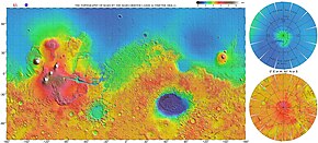
 Vastitas Borealis is the large low elevation area surrounding 70°N. | |
| Location | Northern Hemisphere, Mars |
|---|---|
| Coordinates | 87°44′N 32°32′E / 87.73°N 32.53°E |
| Length | 0–360 E |
| Width | 48.25–82.08 N |
| Diameter | 2002.91 km |
| Depth | 4–5 km |
| Naming | Latin |
Vastitas Borealis (Latin for 'northern waste')[1] is the largest lowland region of Mars. It is in the northerly latitudes of the planet and encircles the northern polar region.[2] Vastitas Borealis is often simply referred to as the northern plains, northern lowlands or the North polar erg[3] of Mars. The plains lie 4–5 km below the mean radius of the planet, and is centered at 87°44′N 32°32′E / 87.73°N 32.53°E.[4] A small part of Vastitas Borealis reaches below 65°N.
The region was named by Eugene Antoniadi, who noted the distinct albedo feature of the Northern plains in his book La Planète Mars (1930). The name was officially adopted by the International Astronomical Union in 1973.[5]
Although it is not an officially recognized feature, the North Polar Basin makes up most of the lowlands in the Northern Hemisphere of Mars.[6][7] As a result, Vastitas Borealis lies within the North Polar Basin, while Utopia Planitia, another very large basin, is adjacent to it. Some scientists have speculated the plains were covered by a hypothetical ocean at some point in Mars' history and putative shorelines have been suggested for its southern edges. Today these mildly sloping plains are marked by ridges, low hills, and sparse cratering. Vastitas Borealis is noticeably smoother than similar topographical areas in the south.
In 2005 the European Space Agency's Mars Express spacecraft imaged a substantial quantity of water ice in a crater in the Vastitas Borealis region. The environmental conditions at the locality of this feature are suitable for water ice to remain stable. It was revealed after overlaying frozen carbon dioxide sublimated away at the commencement of the Northern Hemisphere Summer and is believed to be stable throughout the Martian year.[8]
A NASA probe named Phoenix landed safely in a region of Vastitas Borealis unofficially named Green Valley on 25 May 2008 (in the early Martian summer). Phoenix landed at 68.218830°N 234.250778°E.[9] The probe, which was stationary, collected and analyzed soil samples in an effort to detect water and determine how hospitable the planet might once have been for life to grow. It remained active there until winter conditions became too harsh around five months later.[10]
- ^ Charlton T. Lewis, Charles Short, A Latin Dictionary, Oxford. Clarendon Press. 1879. ISBN 0-19-864201-6 [1]
- ^ "Vastitas Borealis". Gazetteer of Planetary Nomenclature. USGS Astrogeology Science Center. Archived from the original on 23 April 2018. Retrieved 22 April 2021.
- ^ "known as the North polar erg" Archived 30 August 2017 at the Wayback Machine at HiRISE project
- ^ "Planetary Names: Vastitas, vastitates: Vastitas Borealis on Mars". planetarynames.wr.usgs.gov. Archived from the original on 18 April 2017. Retrieved 17 April 2017.
- ^ USGS Planetary Nomenclature[permanent dead link] (click on the feature name for details)
- ^ Andrews-Hanna, Jeffrey C.; Zuber, Maria T.; Banerdt, W. Bruce (1 June 2008). "The Borealis basin and the origin of the martian crustal dichotomy". Nature. 453 (7199): 1212–1215. Bibcode:2008Natur.453.1212A. doi:10.1038/nature07011. ISSN 0028-0836. PMID 18580944. S2CID 1981671.
- ^ "NASA – NASA Spacecraft Reveal Largest Crater in Solar System". nasa.gov. Archived from the original on 22 November 2013. Retrieved 18 April 2017.
- ^ "Water ice in crater at Martian north pole". European Space Agency. Archived from the original on 6 October 2012. Retrieved 4 August 2007.
- ^ Lakdawalla, Emily (27 May 2008). "Phoenix Sol 2 press conference, in a nutshell". The Planetary Society weblog. Planetary Society. Archived from the original on 22 April 2014.
- ^ "Mars lander aims for touchdown in 'Green Valley'". New Scientist Space. 11 April 2008. Archived from the original on 7 September 2012.