Vatheia
Βάθεια | |
|---|---|
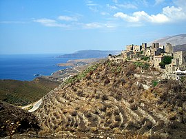
 View of Vatheia | |
| Coordinates: 36°27.2′N 22°28.0′E / 36.4533°N 22.4667°E | |
| Country | Greece |
| Administrative region | Peloponnese |
| Regional unit | Laconia |
| Municipality | East Mani |
| Municipal unit | Oitylo |
| Elevation | 180 m (590 ft) |
| Population (2021)[1] | |
| • Community | 78 |
| Time zone | UTC+2 (EET) |
| • Summer (DST) | UTC+3 (EEST) |
| Postal code | 230 71 |
| Area code(s) | 27330 |
| Website | www |
Vatheia (Greek: Βάθεια [ˈvaθça]; also Vathia) is a village on the Mani Peninsula, in south-eastern Laconia. The local community of Vatheia is named after this village. The aforementioned local community is a subdivision of the municipal unit of Oitylo. It is known for its tower-houses built on a hill dominating the surrounding countryside.
Vatheia is linked by road north to Areopoli and Kalamata and south to Cape Matapan also known as Tenaro. In the northern and eastern direction, the southern reaches of the Sangias mountain range overlook the village. Farmland and maquis shrubland cover the hill slopes. On the hills and mountain sides around Vatheia proper are clusters of abandoned houses, towers and chapels known as the perichora, meaning environs.
Currently, Vatheia is a tourist attraction during spring and summer due to the abundance of wild flowers that cover the nearby hills and its scenic views. Moreover, it is an iconic example of the south Maniot vernacular architecture as it developed during the 18th and 19th centuries. The nearest villages are Kyparissos, Alika and Gerolimenas to the north-west and Lagia to the north-east.
- ^ "Αποτελέσματα Απογραφής Πληθυσμού - Κατοικιών 2021, Μόνιμος Πληθυσμός κατά οικισμό" [Results of the 2021 Population - Housing Census, Permanent population by settlement] (in Greek). Hellenic Statistical Authority. 29 March 2024.
