| Vatinsky Yogan Ватинский Ёган | |
|---|---|
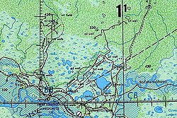
 Course of the Vatinsky Yogan ONC map section | |
Mouth location in Khanty-Mansi Autonomous Okrug, Russia | |
| Location | |
| Country | Russia |
| Physical characteristics | |
| Source | Agansky Yuval, Siberian Uvaly |
| • coordinates | 61°29′15″N 77°00′39″E / 61.48750°N 77.01083°E |
| • elevation | 98 m (322 ft) |
| Mouth | Ob |
• location | Near Langepas |
• coordinates | 61°08′21″N 75°14′59″E / 61.13917°N 75.24972°E |
• elevation | 22 m (72 ft) |
| Length | 593 km (368 mi) |
| Basin size | 3,190 km2 (1,230 sq mi) |
| Basin features | |
| Progression | Ob→ Kara Sea |
The Vatinsky Yogan (Russian: Ватинский Ёган) is a river in Khanty-Mansi Autonomous Okrug, Russia. The river is 593 kilometres (368 mi) long and has a catchment area of 3,190 square kilometres (1,230 sq mi).[1]
The Vatinsky Yogan flows across the Central Siberian Plateau. Its basin is located in the Nizhnevartovsky District. Except for Vysoky there are no permanent settlements along the course of the river, but there are important oil and gas deposits.[2]
- ^ "Река Ватинский Ёган in the State Water Register of Russia". textual.ru (in Russian).
- ^ Cite error: The named reference
GSEwas invoked but never defined (see the help page).
