Vatne Municipality
Vatne herred | |
|---|---|
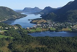
 View of the Vatne area | |
 Møre og Romsdal within Norway | |
 Vatne within Møre og Romsdal | |
| Coordinates: 62°33′24″N 06°38′13″E / 62.55667°N 6.63694°E | |
| Country | Norway |
| County | Møre og Romsdal |
| District | Sunnmøre |
| Established | 1 Jan 1902 |
| • Preceded by | Skodje Municipality |
| Disestablished | 1 Jan 1965 |
| • Succeeded by | Haram Municipality |
| Administrative centre | Vatne |
| Area (upon dissolution) | |
• Total | 139 km2 (54 sq mi) |
| Demonyms | Vatnebygdar Vatnebygder[1] |
| Time zone | UTC+01:00 (CET) |
| • Summer (DST) | UTC+02:00 (CEST) |
| ISO 3166 code | NO-1530[2] |
Vatne is a former municipality in Møre og Romsdal county, Norway. The municipality existed from 1902 until its dissolution in 1965. The 139-square-kilometre (54 sq mi) municipality included land and islands surrounding the Midfjorden and Vatnefjorden in what is now part of Ålesund Municipality and Molde Municipality. The administrative centre was the village of Vatne where Vatne Church is located.[3]
- ^ "Navn på steder og personer: Innbyggjarnamn" (in Norwegian). Språkrådet.
- ^ Bolstad, Erik; Thorsnæs, Geir, eds. (26 January 2023). "Kommunenummer". Store norske leksikon (in Norwegian). Kunnskapsforlaget.
- ^ Thorsnæs, Geir, ed. (2 October 2015). "Vatne - tidligere kommune". Store norske leksikon (in Norwegian). Kunnskapsforlaget. Retrieved 8 June 2019.