Vattavada | |
|---|---|
Village | |
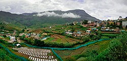
 Farmlands at Vattavada village | |
| Coordinates: 10°11′0″N 77°15′24″E / 10.18333°N 77.25667°E | |
| Country | |
| State | Kerala |
| District | Idukki |
| Taluk | Devikulam |
| Area | |
| • Total | 31.78 km2 (12.27 sq mi) |
| Elevation | 1,659 m (5,443 ft) |
| Population (2001) | |
| • Total | 3,292 |
| • Density | 100/km2 (270/sq mi) |
| Languages | |
| • Official | Malayalam, English[1] |
| • Regional | Tamil,[2]Malayalam |
| Time zone | UTC+5:30 (IST) |
| PIN | 685615 |
| Telephone code | 04865 |
| Vehicle registration | KL-68 |
| Sex ratio | 955:1000 ♂/♀ |
| Literacy | 78% |
| Climate | heavy cool (Köppen) |
Vattavada is a village in Idukki district in the state of Kerala, bordering Tamil Nadu, India.[3] The village is located along Palani Hills in Western Ghats. It is an agricultural village known for growing a wide range of vegetables and fruits in the terrace farmlands.[4]
- ^ "The Kerala Official Language (Legislation) Act, 1969" (PDF).
- ^ "Table C-16 Population by Mother Tongue: Kerala". www.censusindia.gov.in. Registrar General and Census Commissioner of India.
- ^ "Census of India: Villages with population 5000 & above". Registrar General & Census Commissioner, India. Archived from the original on 8 December 2008. Retrieved 10 December 2008.
{{cite web}}: CS1 maint: others (link) - ^ "Why Vattavada is hailed as agricultural haven of Kerala". OnManorama. Retrieved 10 July 2023.
