Vaudreuil-Soulanges | |
|---|---|
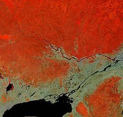
 Vaudreuil-Soulanges is at the triangle (centre right) formed west of the confluence of the Ottawa and Saint Lawrence River rivers in this satellite image. | |
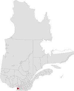
 Location in province of Quebec. | |
| Coordinates: 45°21′N 74°13′W / 45.350°N 74.217°W[1] | |
| Country | |
| Province | |
| Region | Montérégie |
| Effective | April 14, 1982 |
| County seat | Vaudreuil-Dorion |
| Government | |
| • Type | Prefecture |
| • Prefect | Patrick Bousez |
| Area | |
| • Total | 1,019.70 km2 (393.71 sq mi) |
| • Land | 855.56 km2 (330.33 sq mi) |
| Population (2016)[3] | |
| • Total | 149,349 |
| • Density | 174.6/km2 (452/sq mi) |
| • Change 2011-2016 | |
| • Dwellings | 59,474 |
| Time zone | UTC−5 (EST) |
| • Summer (DST) | UTC−4 (EDT) |
| Area code(s) | 450 and 579 |
| Website | www |
Vaudreuil-Soulanges (French pronunciation: [vodʁœj sulɑ̃ʒ]) is a regional county municipality in Quebec, Canada. It is located on a triangular peninsula in the western Montérégie region of Quebec, formed by the confluence of the Ottawa River to the north, and the St. Lawrence River to the south. Ontario is located west of here.
- ^ Cite error: The named reference
toponymiewas invoked but never defined (see the help page). - ^ a b Cite error: The named reference
mamrotwas invoked but never defined (see the help page). - ^ a b "Census Profile, 2016 Census: Vaudreuil-Soulanges, Municipalité régionale de comté [Census division], Quebec". Statistics Canada. 8 February 2017. Retrieved November 26, 2019.