| Venetian Lagoon | |
|---|---|
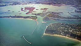
 Aerial view of the Venetian Lagoon, showing many of the islands including Venice itself, center rear, with the bridge to the mainland | |
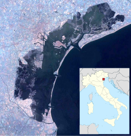
| Location | Venice, Veneto, Italy |
| Coordinates | 45°24′47″N 12°17′50″E / 45.41306°N 12.29722°E |
| Primary outflows | Adriatic Sea |
| Basin countries | Italy |
| Surface area | 550 square kilometres (210 sq mi) |
| Average depth | 10.5 metres (34 ft) |
| Max. depth | 21.5 metres (71 ft) |
| Surface elevation | 3 m (9.8 ft) |
| Settlements | Venice, Campagna Lupia, Cavallino-Treporti, Chioggia, Codevigo, Jesolo, Mira, Musile di Piave, Quarto d'Altino, San Donà di Piave |
| Official name | Laguna di Venezia: Valle Averto |
| Designated | 11 April 1989 |
| Reference no. | 423[1] |
The Venetian Lagoon (Italian: Laguna di Venezia; Venetian: Łaguna de Venesia) is an enclosed bay of the Adriatic Sea, in northern Italy, in which the city of Venice is situated. Its name in the Italian and Venetian languages, Laguna Veneta (cognate of Latin lacus 'lake'), has provided the English name for an enclosed, shallow embayment of salt water: a lagoon.
- ^ "Laguna di Venezia: Valle Averto". Ramsar Sites Information Service. Retrieved 25 April 2018.
