| Ventnor | |
|---|---|
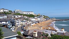
 Ventnor seafront, June 2018 | |
Location within the Isle of Wight | |
| Area | 0.980 sq mi (2.54 km2) |
| Population | 5,567 (2021 Census) |
| • Density | 5,681/sq mi (2,193/km2) |
| OS grid reference | SZ562775 |
| Unitary authority | |
| Ceremonial county | |
| Region | |
| Country | England |
| Sovereign state | United Kingdom |
| Post town | VENTNOR |
| Postcode district | PO38 |
| Dialling code | 01983 |
| Police | Hampshire and Isle of Wight |
| Fire | Hampshire and Isle of Wight |
| Ambulance | Isle of Wight |
| UK Parliament | |
Ventnor (/ˈvɛntnər/) is a seaside resort town and civil parish established in the Victorian era on the southeast coast of the Isle of Wight, England, eleven miles (18 km) from Newport. It is situated south of St Boniface Down, and built on steep slopes leading down to the sea. The higher part is referred to as Upper Ventnor (officially Lowtherville); the lower part, where most amenities are located, is known as Ventnor. Ventnor is sometimes taken to include the nearby and older settlements of St Lawrence and Bonchurch, which are covered by its town council. The population is 5,567 according to the 2021 Census[1]
Ventnor became extremely fashionable as both a health and holiday resort in the late 19th century, described as the 'English Mediterranean' and 'Mayfair by the Sea'. Medical advances during the early twentieth century reduced its role as a health resort and, like other British seaside resorts, its summer holiday trade suffered from the changing nature of travel during the latter part of the century.
Its relatively sheltered location beneath the hilly chalk downland and south-facing orientation towards the English Channel produces a microclimate with more sunny days and fewer frosts than the rest of the island. This allows many species of subtropical plant to flourish; Ventnor Botanic Garden is particularly notable.
