Veradale, Washington
Vera | |
|---|---|
Locale | |
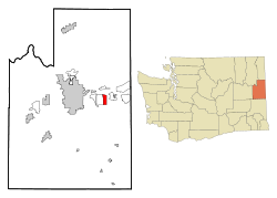
 Location of the CDP of Veradale, Washington at the 2000 Census | |
| Coordinates: 47°39′1″N 117°12′32″W / 47.65028°N 117.20889°W | |
| Country | United States |
| State | Washington |
| County | Spokane |
| Founded | 1911 |
| Founded by | D. K. McDonald |
| Named for | Vera McDonald |
| Area | |
• Total | 3.1 sq mi (8.0 km2) |
| • Land | 3.1 sq mi (8.0 km2) |
| • Water | 0.0 sq mi (0.0 km2) |
| Elevation | 2,024 ft (617 m) |
| Population (2000) | |
• Total | 9,387 |
| • Density | 3,042.3/sq mi (1,174.6/km2) |
| Time zone | UTC-8 (Pacific (PST)) |
| • Summer (DST) | UTC-7 (PDT) |
| ZIP code | 99037 |
| Area code | 509 |
| FIPS code | 53-74725[1] |
| GNIS feature ID | 1512761[A][2] 1511395[B][2] |
Veradale—originally known as Vera—is a locale and former census-designated place in Spokane County, Washington, United States. The population was 9,387 at the 2000 census. Veradale retains its own post office.[3]
- ^ "U.S. Census website". United States Census Bureau. Retrieved 2008-01-31.
- ^ a b "US Board on Geographic Names". United States Geological Survey. 2007-10-25. Retrieved January 12, 2019.
- ^ "Veradale". United States Postal Service. Retrieved June 6, 2019.
Cite error: There are <ref group=upper-alpha> tags or {{efn-ua}} templates on this page, but the references will not show without a {{reflist|group=upper-alpha}} template or {{notelist-ua}} template (see the help page).
