| Verdigris River Van Horner Creek, Vermillion River, Wasetihoge River[1] | |
|---|---|
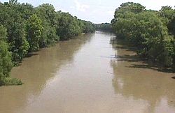
 The Verdigris River near Lenapah, Oklahoma | |
 Map of the Verdigris watershed | |
| Location | |
| Country | United States |
| State | Kansas, Oklahoma |
| Physical characteristics | |
| Source confluence | |
| • location | Madison, Kansas |
| • coordinates | 38°09′08″N 96°10′01″W / 38.15222°N 96.16694°W |
| • elevation | 1,090 ft (330 m) |
| Mouth | Arkansas River |
• location | Muskogee, Oklahoma |
• coordinates | 35°48′01″N 95°18′28″W / 35.80028°N 95.30778°W[1] |
• elevation | 489 ft (149 m) |
| Length | 310 mi (500 km) |
| Discharge | |
| • location | USGS 07176000 near Claremore, OK[2] |
| • average | 4,644 cu ft/s (131.5 m3/s) |
| • minimum | 3.4 cu ft/s (0.096 m3/s) |
| • maximum | 77,700 cu ft/s (2,200 m3/s) |
| Basin features | |
| Progression | Verdigris-Arkansas-Mississippi |
| Tributaries | |
| • right | Fall River, Elk River, Caney River |
| Waterbodies | Toronto Lake, Oologah Lake |
The Verdigris River /ˈvɜːrdɪɡrɪs/ is a tributary of the Arkansas River in southeastern Kansas and northeastern Oklahoma in the United States. It is about 310 miles (500 km) long.[3] Via the Arkansas, it is part of the Mississippi River watershed.
- ^ a b "Verdigris River". Geographic Names Information System. United States Geological Survey, United States Department of the Interior. Retrieved 2015-11-03.
- ^ "Water-Data Report 2013 - 07176000 Verdigris River near Claremore, OK" (PDF). U.S. Geological Survey. Retrieved 2015-11-03.
- ^ U.S. Geological Survey. National Hydrography Dataset high-resolution flowline data. The National Map Archived 2012-03-29 at the Wayback Machine, accessed May 31, 2011