| Verkhoyansk Range | |
|---|---|
| Верхоянский хребет Үөһээ Дьааҥы сис хайата | |
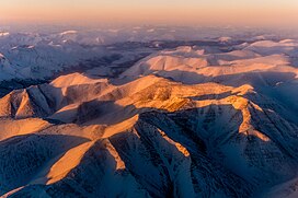
 Aerial view of the Verkhoyansk Mountains | |
| Highest point | |
| Peak | Orulgan high point |
| Elevation | 2,409 m (7,904 ft) |
| Coordinates | 67°N 129°E / 67°N 129°E |
| Dimensions | |
| Length | 1,100 km (680 mi) |
| Geography | |
Location in the Far Eastern Federal District, Russia | |
| Country | Russia |
| State | Sakha Republic |
| Parent range | East Siberian System |
| Geology | |
| Orogeny | Alpine orogeny |
| Rock age | Cretaceous |
| Rock type | Metamorphic rocks |
The Verkhoyansk Range (Russian: Верхоянский хребет, Verhojanskiy Hrebet; Yakut: Үөһээ Дьааҥы сис хайата, Üöhee Caaŋı sis xayata) is a mountain range in the Sakha Republic, Russia near the settlement of Verkhoyansk, well-known for its frigid climate. It is part of the East Siberian Mountains.
The range lies just west of the boundary of the Eurasian and the North American tectonic plates.[1] The mountains were formed by folding, and represent an anticline.[2]
The Verkhoyansk Range was covered by glaciers during the Last Glacial Period and the mountains in the northern section, such as the Orulgan Range, display a typical Alpine relief.
There are coal, silver, lead, tin, and zinc deposits in the mountains.
- ^ News Archive - The Earth Institute at Columbia University
- ^ "Verkhoyansk Mountains". Encyclopædia Britannica. Encyclopædia Britannica, Inc. Retrieved 11 April 2017.
