Vernonia, Oregon | |
|---|---|
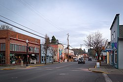
 Downtown Vernonia | |
 Location in Oregon | |
| Coordinates: 45°51′40″N 123°11′00″W / 45.86111°N 123.18333°W | |
| Country | United States |
| State | Oregon |
| County | Columbia |
| Incorporated | 1891 |
| Government | |
| • Mayor | Rick Hobart[1] |
| Area | |
• Total | 1.69 sq mi (4.38 km2) |
| • Land | 1.64 sq mi (4.25 km2) |
| • Water | 0.05 sq mi (0.13 km2) |
| Elevation | 774 ft (236 m) |
| Population | |
• Total | 2,374 |
| • Density | 1,444.92/sq mi (558.05/km2) |
| Time zone | UTC-8 (Pacific) |
| • Summer (DST) | UTC-7 (Pacific) |
| ZIP code | 97064 |
| Area code(s) | 503 and 971 |
| FIPS code | 41-77250[5] |
| GNIS feature ID | 2412152[3] |
| Website | www.vernonia-or.gov |
Vernonia is a city in Columbia County, Oregon, United States. It is located on the Nehalem River, in a valley on the eastern side of the Northern Oregon Coast Range that is the heart of one of the most important timber-producing areas of the state. Logging has played a large role in the history of the city. The population was 2,151 at the 2010 census.
- ^ "Mayor and City Council - City of Vernonia". vernonia-or.gov. Retrieved December 30, 2019.
- ^ "ArcGIS REST Services Directory". United States Census Bureau. Retrieved October 12, 2022.
- ^ a b U.S. Geological Survey Geographic Names Information System: Vernonia, Oregon
- ^ Cite error: The named reference
USCensusDecennial2020CenPopScriptOnlywas invoked but never defined (see the help page). - ^ Cite error: The named reference
wwwcensusgovwas invoked but never defined (see the help page).