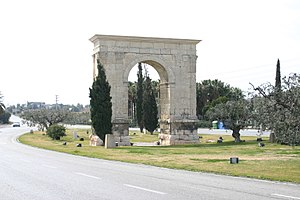
 The Arch of Berá on the Via Augusta | |
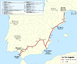
 Route of the Via Augusta | |
| Location | Roman province of Hispania (Spain, southern France) from Gades (Cádiz) to Pertusium (Coll de Pertús) in the Pyrenees |
|---|---|
| Type | Roman road |
| History | |
| Builder | Roman Empire, Augustus Caesar |
| Periods | 8 BC - 2 BC |
The Via Augusta (also known as the Via Herculea or Via Exterior) was the longest and busiest of the major roads built by the Romans in ancient Hispania (the Iberian Peninsula). According to historian Pierre Sillières, who has supervised excavation of Roman sites in Spain to identify the exact route followed by the Via Augusta, it was more a system of roads than a single road.[1][2] Approximately 1,500 km (930 mi) long, the Via Augusta was built to link Spain with Italy, running from the southwestern coastal city of Gades (Cádiz) to the Pyrenees Mountains along inland valleys parallel to the coast of the Mediterranean Sea. As the main axis of the road network in Roman Hispania,[3] it appears in ancient sources such as the itinerary inscribed on the Vicarello Cups[4] as well in as the Antonine Itinerary.
The highway was named after the emperor Augustus, who ordered reconstruction of the previously existing Via Herculea (or Via Heraklea), which ran from the Pyrenees to Carthago Nova, and extension of the arterial roadway as far as Gades.[5] The works were carried out between 8 BC and 2 BC,[6][7] taking advantage of what remained of roads that had existed in the time of the Roman Republic.[8] Subsequently, it became an important communications and trade route between the cities and provinces and the ports of the Mediterranean. The Via Augusta was still used by the Moors of southern Spain in the 10th century,[9] who called it al-Racif. Its route is currently followed by the N-340 road and the A-7 highway. North of Tarragona there remains a Roman Triumphal arch, the Arc de Berà, around which the road divides. At Martorell, the ancient Via crosses the river Llobregat on the Pont del Diable,[10] which dates from the High Middle Ages (circa 1289) in its current form. At present, the N-IV N-420, N-340 and the Mediterranean Highway ( A-7, AP-7, A-70 ) follow the same itinerary in many sections as the Vía Augusta. In some sections of the current N-340, the Roman road was used until the 1920s, when they were paved during the dictatorship of Primo de Rivera.
- ^ Cite error: The named reference
BowmanChamplin1996was invoked but never defined (see the help page). - ^ Georges Castellvi, ed. (1997). Voies romaines du Rhône à l'Èbre: via Domitia et via Augusta. Éditions de la Maison des sciences de l'homme. p. 292. ISBN 9782735106332.
- ^ Joseph F. O'Callaghan (15 April 2013). A History of Medieval Spain. Cornell University Press. p. 33. ISBN 978-0-8014-6871-1.
- ^ Lesley Adkins; Roy A. Adkins (14 May 2014). Handbook to Life in Ancient Rome. Infobase Publishing. pp. 188–. ISBN 978-0-8160-7482-2.
- ^ Archaeology. Archaeological Institute of America. 1951. p. 5.
- ^ Ramsay MacMullen (2000). Romanization in the Time of Augustus. Yale University Press. pp. 57–. ISBN 978-0-300-12990-8.
- ^ Xavier Allepuz Marzà (1 January 2003). Borriol. Publicacions de la Universitat Jaume I. p. 270. ISBN 978-84-8021-413-1.
- ^ Enrique Melchor Gil (2013). "La red viaria romana en la comarca del Alto Guadalquivir: la zona de Villafranca de Córdoba". In Luis Segado Gómez (ed.). Orígenes históricos de Villafranca de Córdoba (in Spanish). Universidad de Córdoba, Servicio de Publicaciones. p. 103. ISBN 978-84-9927-127-9.
English: The main Roman road traversing the province of Córdoba was the Via Augusta, built by order of the emperor, and taking advantage of the network of roads that had existed since the era of the Roman Republic. The road communicated Rome with Gades, passing through Tarraco, Carthago Nova and the four capitals of the legal convents of Betica (Corduba, Astigi, Hispalis and Gades). This was a public road built and maintained by the Roman administration, on which the cursus publicus, or the courier and transportation system of the imperial administration, was established. Therefore, the Via Augusta facilitated the government and administration of the province of Baetica, as well as the movement of the armies when necessary.
- ^ Federico Pallí Aguilera (1 January 1985). La Vía Augusta en Cataluña. Universidad Autónoma de Barcelona. p. 127. ISBN 978-84-7488-125-7.
- ^ Xavier Dupré i Raventós (1994). L'arc romà de Berà: Hispania Citerior. Institut d'Estudis Catalans. p. 248. ISBN 978-84-7283-274-9.