| Victoria River | |
|---|---|
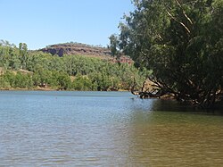
 Victoria River access, near the roadhouse Victoria River crossing | |
| Etymology | Queen Victoria[1] |
| Location | |
| Country | Australia |
| Territory | Northern Territory |
| Region | Victoria Bonaparte (IBRA) |
| Physical characteristics | |
| Source | Mount Farquharson |
| • coordinates | 17°28′16.1436″S 130°49′39.6048″E / 17.471151000°S 130.827668000°E |
| • elevation | 364 m (1,194 ft) |
| Mouth | Joseph Bonaparte Gulf |
• coordinates | 14°56′50″S 129°33′15″E / 14.94722°S 129.55417°E |
• elevation | 0 m (0 ft) |
| Length | 560 km (350 mi) |
| Basin size | 87,900 km2 (33,900 sq mi) to 99,412.5 km2 (38,383.4 sq mi)[2] |
| Discharge | |
| • location | Near mouth |
| • average | (Period: 1971–2000)345.7 m3/s (10,910 GL/a)[2] 158.4 m3/s (5,590 cu ft/s) |
| Basin features | |
| River system | Victoria River |
| Tributaries | |
| • left | Wickham, Baines, Bullo |
| • right | Camfield, Angalarri |
| National park | Judbarra / Gregory NP |
| [3][4] | |
The Victoria River is a river in the bioregion of Victoria Bonaparte in the Northern Territory of Australia. It flows for 560 kilometres (350 mi) from its source south of the Judbarra / Gregory National Park to the Joseph Bonaparte Gulf in the Timor Sea.
- ^ Cite error: The named reference
sahistorywas invoked but never defined (see the help page). - ^ a b "Victoria".
- ^ Cite error: The named reference
Bonzlewas invoked but never defined (see the help page). - ^ "Overview of the Victoria River Catchment" (PDF). Top End Waterways Project. 2005. Retrieved 29 September 2014.
