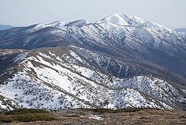
| Victorian Alps | |
|---|---|
| Victoria Alps, High Plains, High Country, The Alps | |
 Mount Feathertop and the Razorback | |
| Highest point | |
| Peak | Mount Bogong |
| Elevation | 1,986 m (6,516 ft)[1] AHD |
| Coordinates | 36°43′56″S 147°18′21″E / 36.73222°S 147.30583°E[2] |
| Dimensions | |
| Length | 400 km (250 mi) NE-SW (approx) |
| Width | 200 km (120 mi) E-W (approx) |
| Area | 5,199 km2 (2,007 sq mi)[3] |
| Geography | |
Location of the Victorian Alps in Victoria | |
| Country | Australia |
| Region | Victoria |
| Range coordinates | 36°44′S 147°18′E / 36.733°S 147.300°E[4] |
| Parent range | Great Dividing Range |
| Borders on | New South Wales |
| Geology | |
| Rock age | Devonian |
| Rock types | |
The Victorian Alps, also known locally as the High Country, is a large mountain system in the southeastern Australian state of Victoria. Occupying the majority of eastern Victoria, it is the southwestern half of the Australian Alps (the other half being the Snowy Mountains), the tallest portion of the Great Dividing Range. The Yarra and Dandenong Ranges, both sources of rivers and drinking waters for Melbourne (Victoria's capital, largest city and home to three quarters of the state's population), are branches of the Victorian Alps.
The promise of gold in the mid-1800s, during the Victorian Gold rush led to the European settlement of the area.[5] The region's rich natural resources brought a second wave of agricultural settlers; the foothills around the Victorian Alps today has a large agrarian sector, with significant cattle stations being sold recently for over thirty million dollars.[6] The Victorian Alps is also the source of many of Victoria's water ways, including Murray and Yarra Rivers and the Gippsland Lakes.[5] The valleys beneath the high plains are surrounded by wineries and orchards because of this abundance of water.[7] The region is also home to Victoria's largest national park, the Alpine National Park, which covers over 646,000 hectares (1,600,000 acres).[8][5] The establishment of the Alpine National Park has meant that economic activities such as mining, logging and agriculture are limited, to preserve the natural ecosystem for visitors.[5] Tourism within the region centres around snow sports in winter and various outdoor activities during the summer months.[7]
The Australian Alps is an Interim Biogeographic Regionalisation for Australia sub-bioregion of approximately 519,866 hectares (1,284,620 acres),[3] and an administrative sub-region of Victoria bordering the Gippsland and Hume regions.
- ^ Cite error: The named reference
pbwas invoked but never defined (see the help page). - ^ "Mount Bogong". Gazetteer of Australia online. Geoscience Australia, Australian Government.
- ^ a b "Australia's bioregions (IBRA)". Department of Sustainability, Environment, Water, Population and Communities. Commonwealth of Australia. 2012. Retrieved 21 January 2014.
- ^ "Victoria Alps [sic]". Peakbagger.com.
- ^ a b c d "the Australian alps". Australian Alps national parks Co-operative Management Program 2020. 19 November 2013. Retrieved 9 April 2020.
- ^ Carberry, Kirrily (7 February 2019). "Rural Funds Group buys beef farm Cobungra Station". Retrieved 26 May 2020.
- ^ a b Jemison, C. "High Country Online". High Country Online. Retrieved 9 April 2020.
- ^ Visit Bright. "Alpine National Park". Visit Bright. Retrieved 26 May 2020.
