Vila do Porto | |
|---|---|
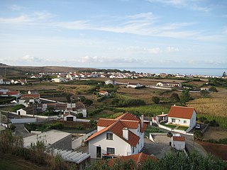
 View of Vila do Porto from outside of the Hotel Colombo | |
 Location of Vila do Porto in the Azores | |
| Coordinates: 36°56′53″N 25°08′42″W / 36.948°N 25.145°W | |
| Country | |
| Auton. region | Azores |
| Island | Santa Maria |
| Settled | c. 1460 |
| Parishes | |
| Government | |
| • Type | Municipal Chamber |
| • Chamber Pres. | Bárbara Pereira Torres de Medeiros Chaves |
| • Assembly Pres. | João Manuel Andrade Fontes |
| • Council Pres. | Maria Dulce de Oliveira Resendes |
| Area | |
| • Total | 96.89 km2 (37.41 sq mi) |
| Elevation | 242 m (794 ft) |
| Population (2021) | |
| • Total | 5,408 |
| • Density | 56/km2 (140/sq mi) |
| Time zone | UTC-01:00 (AZOT) |
| • Summer (DST) | UTC±00:00 (AZOST) |
| Postal code | 9580-539 |
| Area code | 292 |
| Patron | Our Lady of the Assumption |
| Local holiday | August 15 |
| Website | cm-viladoporto |
Vila do Porto (Portuguese pronunciation: [ˈvilɐ ðu ˈpoɾtu] ; "Port Town") is the single municipality, the name of the main town and one of the civil parishes on the island of Santa Maria, in the Portuguese archipelago of Azores. Its nearest neighbor, administratively, is the municipality of Povoação on the southern coast of São Miguel (to the northwest), and it is physically southwest of the islets of the Formigas. The population in 2021 was 5,408,[1] in an area of 96.89 km2 (37.41 sq mi).[2]
- ^ "Resident population (No.) by Place of residence, Sex and Marital status; Decennial - 2021". Statistics Portugal. Instituto Nacional de Estatística. December 16, 2021. Archived from the original on August 15, 2022. Retrieved August 15, 2022.
- ^ "Portugal - Local Administrative Unit NUTS3 Correspondence Table and Land Use Data" (XLS). Eurostat. Archived from the original (XLS) on October 7, 2012.

