This article needs additional citations for verification. (March 2023) |
Vilhena | |
|---|---|
Municipality | |
| The Municipality of Vilhena | |
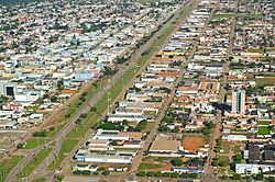
 Aerial view of Vilhena | |
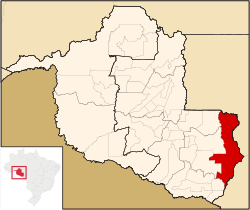
 Location of Vilhena in the State of Rondônia | |
| Coordinates: 12°44′26″S 60°08′45″W / 12.74056°S 60.14583°W | |
| Country | |
| Region | North |
| State | |
| Founded | November 23, 1977 |
| Government | |
| • Mayor | Flori Cordeiro (PODE) |
| Area | |
| • Total | 11,519 km2 (4,448 sq mi) |
| Elevation | 615 m (2,018 ft) |
| Population (2020 [1]) | |
| • Total | 102,211 |
| • Density | 5.5/km2 (14/sq mi) |
| Time zone | UTC−4 (AMT) |
| HDI (2000) | 0.771 – medium[2] |
| Website | www.vilhena.ro.gov.br |
12°44′26″S 60°08′45″W / 12.74056°S 60.14583°W Vilhena (pronounced [viˈʎenɐ]) is the easternmost municipality in the Brazilian state of Rondônia. Its population was 102,211 (IBGE-2020) and its area is 11,519 km2.[3] It is the fifth-largest city in Rondônia and has the best HDI in the state (0,771 – UNDP/2000). According to IBGE-2015, Vilhena also had a GDP of R$1.824.367,69(approximately US$460 million), which represented a GDP per capita of R$23.055,20 (around US$6.000,00)

