Vinger Municipality
Vinger herred | |
|---|---|
 View of Vinger Church | |
 Hedmark within Norway | |
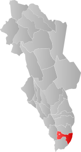
 Vinger within Hedmark | |
| Coordinates: 60°11′42″N 12°00′38″E / 60.19488°N 12.01049°E | |
| Country | Norway |
| County | Hedmark |
| District | Vinger |
| Established | 1 Jan 1838 |
| • Created as | Formannskapsdistrikt |
| Disestablished | 1 Jan 1964 |
| • Succeeded by | Kongsvinger Municipality |
| Administrative centre | Kongsvinger |
| Area (upon dissolution) | |
• Total | 499 km2 (193 sq mi) |
| Population | |
• Total | 6,257 |
| • Density | 13/km2 (32/sq mi) |
| Demonym | Vingersokning[1] |
| Time zone | UTC+01:00 (CET) |
| • Summer (DST) | UTC+02:00 (CEST) |
| ISO 3166 code | NO-0421[2] |
Vinger is a former municipality in the old Hedmark county, Norway. The 499-square-kilometre (193 sq mi) municipality existed from 1838 until 1964 when it became part of Kongsvinger Municipality. The municipality was located in the Vinger region in the southern part of the county, along the border with Sweden. The administrative centre of Vinger was located in the town of Kongsvinger where Vinger Church is located (the town was not actually part of the municipality, but this was where the councils met).[3]
- ^ "Navn på steder og personer: Innbyggjarnamn" (in Norwegian). Språkrådet.
- ^ Bolstad, Erik; Thorsnæs, Geir, eds. (26 January 2023). "Kommunenummer". Store norske leksikon (in Norwegian). Kunnskapsforlaget.
- ^ Mæhlum, Lars, ed. (10 February 2020). "Vinger". Store norske leksikon (in Norwegian). Kunnskapsforlaget. Retrieved 18 March 2022.