You can help expand this article with text translated from the corresponding article in German. (July 2011) Click [show] for important translation instructions.
|
This article needs additional citations for verification. (February 2017) |
Viqueque | |
|---|---|
| |
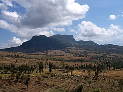
 Rice fields in Viqueque | |
 | |
| Coordinates: 8°47′S 126°22′E / 8.783°S 126.367°E | |
| Country | |
| Capital | Viqueque |
| Administrative posts | |
| Area | |
• Total | 1,872.7 km2 (723.1 sq mi) |
| • Rank | 1st |
| Population (2015 census) | |
• Total | 73,033 |
| • Rank | 5th |
| • Density | 39/km2 (100/sq mi) |
| • Rank | 10th |
| Households (2015 census) | |
| • Total | 15,297 |
| • Rank | 5th |
| Time zone | UTC+09:00 (TLT) |
| ISO 3166 code | TL-VI |
| HDI (2017) | 0.602[1] medium · 9th |
| Website | Viqueque Municipality |
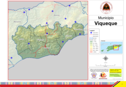
Viqueque (Portuguese: Município Viqueque, Tetum: Munisípiu Vikeke) is the largest of the municipalities (formerly districts) of East Timor. It has a population of 77,402 (Census 2010) and an area of 1,877 km2.[2] The capital of the municipality is also named Viqueque.
- ^ "Sub-national HDI - Area Database - Global Data Lab". hdi.globaldatalab.org. Retrieved 13 September 2018.
- ^ "VIQUEQUE EM NÚMEROS: ESTATÍSTICA MUNICÍPIO DE VIQUEQUE" (PDF). Statistic Timor-Leste. 2014. Retrieved 22 February 2017.


