Virgilina, Virginia | |
|---|---|
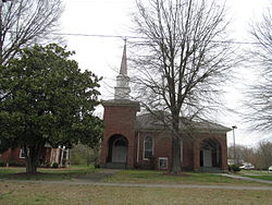
 Union Christian Church | |
 Location of Virgilina, Virginia | |
| Coordinates: 36°32′43″N 78°46′25″W / 36.54528°N 78.77361°W | |
| Country | United States |
| State | Virginia |
| County | Halifax |
| Government | |
| • Mayor | Ralph Murray |
| Area | |
| • Total | 0.62 sq mi (1.60 km2) |
| • Land | 0.61 sq mi (1.59 km2) |
| • Water | 0.00 sq mi (0.01 km2) |
| Elevation | 551 ft (168 m) |
| Population (2010) | |
| • Total | 275 |
| • Estimate (2019)[2] | 252 |
| • Density | 223.13/sq mi (86.15/km2) |
| Time zone | UTC−5 (Eastern (EST)) |
| • Summer (DST) | UTC−4 (EDT) |
| ZIP code | 24598 |
| Area code | 434 |
| FIPS code | 51-81312[3] |
| GNIS feature ID | 1493858[4] |
Virgilina is a town in Halifax County, Virginia, United States. The population was 275 at the 2010 census.[5] Virgilina was once a copper mining town. It was a stop on the Atlantic and Danville Railway as recently as the 1950s. It is named "Virgilina" because it is located on the Virginia and North Carolina border.
- ^ "2019 U.S. Gazetteer Files". United States Census Bureau. Retrieved August 7, 2020.
- ^ Cite error: The named reference
USCensusEst2019CenPopScriptOnlyDirtyFixDoNotUsewas invoked but never defined (see the help page). - ^ "U.S. Census website". United States Census Bureau. Retrieved January 31, 2008.
- ^ "US Board on Geographic Names". United States Geological Survey. October 25, 2007. Retrieved January 31, 2008.
- ^ "Geographic Identifiers: 2010 Census Summary File 1 (G001): Virgilina town, Virginia". American Factfinder. U.S. Census Bureau. Archived from the original on February 13, 2020. Retrieved March 21, 2018.