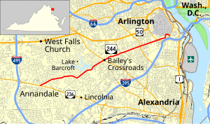
State highway in northern Virginia, US
State Route 244 (SR 244) is a primary state highway in the U.S. state of Virginia. Known as Columbia Pike, the state highway runs 4.58 miles (7.37 km) from SR 236 in Annandale to the Arlington County line. Columbia Pike continues east to SR 27 and Interstate 395 (I-395) at The Pentagon in Arlington. Columbia Pike is a major southwest–northeast thoroughfare in northeastern Fairfax County and eastern Arlington County, connecting Annandale with SR 7 at Bailey's Crossroads and SR 120 in the multicultural Westmont neighborhood of Arlington.
- ^ a b Cite error: The named reference
VDOT Traffic Data was invoked but never defined (see the help page).

