 | ||||
| Route information | ||||
| Maintained by VDOT | ||||
| Length | 61.20 mi[1][2][3] (98.49 km) | |||
| Existed | July 1, 1933[4]–present | |||
| Tourist routes | ||||
| Altavista – Blue Ridge Parkway | ||||
| Length | 39.79 mi[1][2] (64.04 km) | |||
| South end | ||||
| Major intersections | ||||
| North end | ||||
| Blue Ridge Parkway – Eagle Rock | ||||
| Length | 21.41 mi[3] (34.46 km) | |||
| South end | ||||
| Major intersections | ||||
| North end | ||||
| Location | ||||
| Country | United States | |||
| State | Virginia | |||
| Counties | Campbell, Bedford, Botetourt | |||
| Highway system | ||||
| ||||
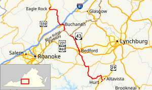
State Route 43 (SR 43) is a primary state highway in the U.S. state of Virginia. The state highway consists of two disjoint segments that have a total length of 61.20 miles (98.49 km). The southern portion of the state highway runs 39.79 miles (64.04 km) from U.S. Route 29 Business (US 29 Bus.) in Altavista north to the Blue Ridge Parkway at Peaks of Otter. The northern segment has a length of 21.41 miles (34.46 km) between the Blue Ridge Parkway near Buchanan and US 220 in Eagle Rock. The two sections of SR 43 are connected by 4.9 miles (7.9 km) of the Blue Ridge Parkway. The southern portion of the state highway connects Altavista with Bedford and Peaks of Otter. The northern section of SR 43 follows the James River through a narrow valley (Narrow Passage Road) between Buchanan and Eagle Rock.
SR 43 is a Virginia Byway except south of the US 29 bypass of Altavista.[5][6]
- ^ a b Cite error: The named reference
Campbell Traffic Datawas invoked but never defined (see the help page). - ^ a b Cite error: The named reference
Bedford Traffic Datawas invoked but never defined (see the help page). - ^ a b Cite error: The named reference
Botetourt Traffic Datawas invoked but never defined (see the help page). - ^ "New Numbers of Va. Highways Effective July 1". The Richmond Times-Dispatch. May 10, 1933. p. 5. Retrieved January 21, 2020 – via Newspapers.com.

- ^ Commonwealth Transportation Board (December 20, 1990). "Minutes of Meeting" (PDF) (Report). Richmond: Commonwealth of Virginia. p. 32.
- ^ Commonwealth Transportation Board (December 17, 1992). "Minutes of Meeting" (PDF) (Report). Richmond: Commonwealth of Virginia. p. 26.
