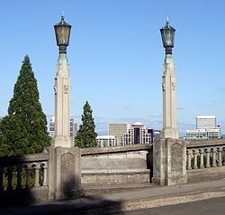
Vista Bridge | |
|---|---|
 Viewed from Jefferson Street, towards downtown | |
| Coordinates | 45°31′09″N 122°41′52″W / 45.5191°N 122.6978°W |
| Carries | Vista Avenue and pedestrians |
| Crosses | MAX Light Rail line and Jefferson Street/Canyon Road |
| Locale | Portland, Oregon |
| Maintained by | Multnomah County |
| Characteristics | |
| Total length | 248 ft |
| Height | 120 ft |
| History | |
| Opened | 1926[1][2] |
Vista Avenue Viaduct | |
Portland Historic Landmark[4] | |
 Detail of light standards and benches mid-span, and view of downtown and east Portland | |
| Location | 1200 SW Vista Avenue Portland, Oregon |
| Coordinates | 45°31′09″N 122°41′52″W / 45.519097°N 122.697844°W |
| Built | 1926 |
| NRHP reference No. | 84003093[3] |
| Added to NRHP | April 26, 1984 |
The Vista Bridge (officially, Vista Avenue Viaduct) is an arch bridge for vehicles and pedestrians located in Portland, Oregon, United States. It connects the areas of King's Hill and Vista Ridge (the entire southern hillside is also referred to as Portland Heights) which are both in the Goose Hollow neighborhood.[5] The MAX Light Rail line and Jefferson Street/Canyon Road travel under the bridge, and Vista Avenue crosses the bridge.
- ^ Portland Transportation History Timeline
- ^ The placards at the north end of the bridge say 1925. See photograph.
- ^ Cite error: The named reference
ORNRHPwas invoked but never defined (see the help page). - ^ Portland Historic Landmarks Commission (July 2010), Historic Landmarks -- Portland, Oregon (XLS), retrieved November 13, 2013.
- ^ Prince, Tracy J. (2011). Portland's Goose Hollow. Charleston, South Carolina: Arcadia Publishing. pp. 2, 8–10. ISBN 978-0-7385-7472-1.
